There is little that can be more frustrating than being denied access to your destination at the last possible moment – that arriving at closing time, unexpected locked door, security guards, not open on a Sunday feeling.
I had just that feeling on a recent visit to an extremely rare extant (potentially) prehistoric monument in central London, the Hampstead Heath tumulus aka Boudica’s Grave. During an epic day visiting all of the mythical mounds of London as written about by EO Gordon in 1914 (of more below) I went off piste to have a look at a much less mythical actual mound and was met with a padlocked gate!
This earthwork monument is located in the southern half of Hampstead Heath, a large park north of the Thames with expansive views over the city to the south from Parliament Hill. On the day I visited it was a rather dreich and muddy affair, but the weather conditions did add a certain autumnal majesty to the tree-crowned barrow from afar.
What of the archaeology and history of this urban barrow? The monument is Scheduled by Historic England, and the most succinct summary account is to be found in their listing of the monument (here):
“The monument includes a bell barrow situated near the summit of Parliament Hill, south of Highgate Ponds at Hampstead Heath. It survives as a roughly circular-shaped mound, 36m in diameter and up to 3m high. Around the barrow is a berm or platform varying between 3.5m and 4.5m wide. Surrounding this is a quarry ditch, varying between 4.8m and 6m wide, from which material to construct the barrow was derived. The barrow was partially excavated by Charles Read in 1894 but only pieces of charcoal were recovered. Read concluded that the burial may have completely decomposed given the acidity of the soil. The barrow is shown in a drawing of 1725 by the antiquarian William Stukeley. The name of the barrow is derived from a local tradition stating it was the site of Boadicea’s (or Boudica’s) grave. Boadicea was the queen of the Iceni tribe who led an uprising against the occupying Roman forces in about AD 60. The monument excludes the modern path which impinges on the monument, all marker posts, modern fences and fence posts, gates and gate posts but the ground beneath all these features is included”.
There is no evidence at all that this has anything to do with Boudica and I could find no reference to this local myth in Duncan Mackay’s excellent 2023 book Echolands: a journey in search of Boudica, suggesting that his journey did not take him to the Heath. Nor is there much concrete (as it were) to confirm a prehistoric origin either although the morphology and location of the mound are suggestive. There is also some confirmatory context in the shape of later prehistoric materials found on nearby Parliament Hill during excavations in 2017, including the by now obligatory prehistory BBQ spin.
Much earlier excavations of the tumulus itself in the 1890s carried out by Charles Hercules Read were inconclusive in any one direction, despite there being a plan – apparently – to install a huge statue of the Iron Age warrior queen should this work confirm that this was indeed Boudica’s final resting place. The charcoal that was recovered by Reid may well have been vital pieces of evidence although they would not have been recognised as such back then, and no longer exist.
The official Hampstead Heath website is more circumspect about the ancient origins of this monument, noting: “…maps from the 16th Century show the area covered in dense woodland – any older burial mound would have been destroyed by tree roots. The explanation considered most likely is that the mound was made in the 17th Century, possibly for a windmill after the woodland was cleared, and the trees planted later (though there are no paintings of that windmill, and lots of paintings of the trees).” They also include a lovely painting of the mound from 1820 pre-fence and pre-padlock.
I visited with no pre-conceptions, other than that the park would probably not look like the reconstruction drawing included in Nick Merriman’s 1990 book Prehistoric London. Here we have the Heath as Mesolithic hunting zone, supported by the discovery of many thousands of lithics and evidence for a ‘hunting camp’ in the park back in the 1970s. These were not barrow-building folk, but this does indicate some epic deep time in central London.
I was on a mission to visit – as stated earlier – the location of the four ancient mounds of London as documented by EO Gordon is the eccentric 1914 book Prehistoric London: It’s mounds and circles, for a book chapter I am writing. Gordon has very little to say about ‘Boudicea’s Grave’, being much more fixated on nearby Parliament Hill as being a mythical Silbury Hill-like foundational London mound. (I suppose the discovery of Bronze Age BBQ waste here in 2017 is interesting in this respect.)
After taking in the dreary and damp view from Parliament Hill, I walked to the barrow site via several of the many desire lines that criss-cross this part of the park, eventually emerging into a broad grassy vista with the tree-topped mound ahead. As I walked over to the site across damp grass with fewer desire lines the outline of the barrow began to describe itself to me, shrouded in trees and shrubs. It was surrounded by an austere black iron fence with spikes atop each upright which dissuaded me from climbing over, even although they were not that high, as I had visions of having to be air-lifted from the Heath with a spike through my thigh. Fresh from a First Aid course the week before I didn’t want to experience arterial spurting up close. The mound is also surrounded by a setting of park benches, some with dedications carved into them, all looking outwards for the views, not inwards for the tumulus.
I circumnavigated the barrow, noting that no clues were evident as to the age, origin or function of the monument. There was not even an information board that might help the visitor to make sense of things, and the only QR code I could see – on a stumpy low post inside the fence line – took one to the general Hampstead Heath website. Just beyond the fence on the north-west side of the mound was a small hedgehog house, suggesting another type of spike altogether.
And then I reached the padlocked gate, a full 310 degrees from my starting point, having walked around the mound in a counter-clockwise direction. I was surprised that access was not allowed onto the mound itself, and found myself wondering who had the key for the padlock.
This person has the power to come up here and night, let themselves into the fenced compound, and enjoy the freedom of the mound – and perhaps they do. This kind of control reflects the ways that access to the dead may have been mediated by certain members of society 4000 years ago, but sits less comfortably in our era of transparency. I noticed also at the bottom of the gate was an abandoned pair of glasses, perhaps discarded in an aborted attempt to get over the gate or pick the lock.
We should leave the last words on this matter to Caroline White, in her 1900 book Sweet Hampstead and its Associations.
Tumulus. From Sweet Hampstead, possibly by a Mr. P. Forbes
“But whatever its origin, the mound adds materially to the visual enjoyment of the visitor; and the sight of London from its height, especially at the early dawn of a clear summer’s day, is said to be worth a midnight pilgrimage to obtain. The air blows over its summit ‘most sweetly,’ especially in June, blending the scent of the lime blossoms from the sister villages with the aroma of the hayfields and hedgerows, where the honeysuckle and wild-rose bloom unmolested”.
Rain or shine, Bronze Age or post-medieval folly, padlock or no padlock, this is a fine earthwork in a fine location. I just wish that we could be trusted to be allowed in.
Urban prehistory can be transformational, but it can also be mundane, generating little more than footnotes. When all is said and done, the discovery of ancient pots and precious bones is just another part of the relentless tireless digging in that humans have always done, extracting, replacing, destroying, creating. The ground surface is a gateway to the past but also a pointer to the future and our own bodily and material mortality.
On Wednesday 25th of March 1885, during road construction works in a field and the creation of the leafy suburb of Kylepark in the Lanarkshire town of Uddingston, two large ancient pots were found within a foot of the ground surface. “Both urns, in accordance with a not unusual practice, had been merely placed in the earth mound downwards over the bones they were intended to protect” (Duncan 1885, pg. 337).
A few days later, the then Honorary Secretary of the Glasgow Archaeological Society, J Dalrymple Duncan*, visited to take charge of the site and he carried out what must have been a fairly rudimentary investigation of the findspot, just a stone’s throw from the River Clyde. Before he arrived some human bones had also been found, and so Dalrymple “had the ground dug up for a considerable space around the spot, when after some search we were successful in discovering a few small portions of a third urn” (pg. 337).
J Dalrymple Duncan / Gray (University of Glasgow)
JDD collected together the fragments of urn that had already been found, to be passed to Joseph Anderson of the National Museum of Antiquities. For one of the urns was damaged by a pick axe, the other had been squashed by a construction tramway inadvertantly laid over it. The third urn survived only as ‘trifling portion’.
The human remains were analysed by Professor Young of Glasgow University and Professor Buchanan of Anderson’s College. They could not say much with certainty but suggested that there were at least two people represented, perhaps an older short man, and a slighter younger person, “inextricably mixed together”.
And so the road was completed, and the houses constructed, what was once a riverside field, now sandstone homes, gardens, and trackways. The wheels of time moved on, with the location of this remarkable discovery – what we would now know to be a 4,000 year old burial site – settling in to its comfortable middle class future.
The interpretation of this modest discovery was associated with the Bronze Age by Dalrymple, and noteworthy as, “the first instance … of one of these having been brought to light in the immediate neighbourhood of Glasgow” (pg. 340).
In 1904, a local history book was published called By Bothwell banks: some chapters on the history, archaeology and literary associations of the Uddingston and Bothwell district, written by George Henderson and architect J Jeffrey Waddell. This documented for the most part the medieval and later history of this area, with Bothwell and Uddingston being neighbouring towns on the banks of the Clyde.
The first three pages of this narrative explore what the authors call the ‘earliest times’ and they make note of the discovery of the urns and bones at Kylepark, as well as – in a footnote to this footnote – mention of another Bronze Age discovery at Viewpark to the north in the early years of the nineteenth century. The discovery at Kylepark was loosely connected to local folk traditions.
Looking back to these ancient days, the authors cannot help fall back on colonial narratives of the uncivilised, exotic nature of these prehistoric folk. The river would have had,
“banks luxurious with vegetation of almost tropical growth, overshadowed with gigantic trees, with its waters as yet unsullied by civilisation, would be as well stocked with the lordly salmon as any river in Canada”.
They continued, “…hunting and fishing would have occupied their days, varied only by such gentle relaxation as tribal war” (pg. 2).
Such narratives recall the fantastical writing of Ludovic McLellan Mann in his 1937 book Earliest Glasgow: Temple of the Moon. Earliest man “watched with awe and eagerness the great mammalia striding across the meadows and through the woodlands” (pg. 1). Mann will appear again in our story before the end.
There is a curious conflicted view of colonialism within the Henderson and Waddell narrative, who on the one hand treat prehistoric people as if they were a lesser, different species, and on the other hand bitterly note the ‘iron foot’ of the subsequent Roman invaders of Strathclyde. There seems to be a recognition that in ‘civilising’ someone, you change them and their environment in not altogether positive ways. Yet there is also a strand of continuity from these folk, with a note that the nearby location of a church means that this ground was “hallowed … by many forms of worship”. And of course these Bronze Age dead – whose bones were picked over by Professors – were pagans.
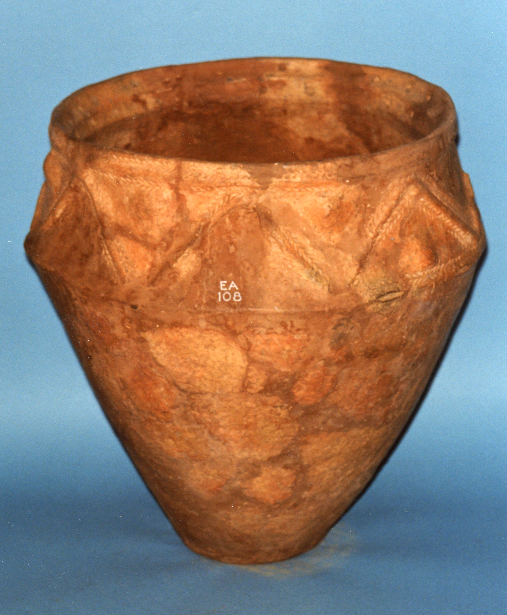
The houses were constructed, the road established, middle classes became entrenched, people slotting into types just as surely as the pots that were found at Kylepark. The three vessels were studied at a visual level, being drawn (see above) and characterised – two urns, one of the encrusted type, and one Food Vessel. These were distributed widely, held across two museums in Glasgow and Edinburgh, where they still reside today in cardboard boxes in environmentally controlled museum stores.
X.EA 108 Encrusted pottery urn with band of raised zigzags and bosses on upper part, from Uddingston, Lanarkshire, Middle Bronze Age. Clay; band of raised zigzags and bosses on upper part (source).
Source: National Museums of Scotland
This and the other vessels have from time to time been of use to archaeologists.
In 1933, Ludovic Mann addressed a fieldtrip of the Glasgow Archaeological Society and the Scottish Ecclesiological Society in Bothwell, close to the Kylepark discovery. There he outlined an outlandish argument that the current location of St Bride’s Church in Bothwell was indicative of a prehistoric sacred landscape on a par with Stonehenge. His theories were developed in story in the local newspaper The Hamilton Advertiser a week later, a story Mann was so enamoured with he had made into a pamphlet.
The detail and contextualisation of Mann’s lecture and demonstrations that day will be the subject of a more detailed examination (link to be added when this is published) but suffice to say that of course the Kylepark discovery was surely of interest to Mann’s theorising. “Bothwell must have been a very notable place in pre-Christian times…” (pg. 3) and it is probable that the urn findspot was included on a large map Mann brought for the occasion and used as the basis for an illustrated talk at the Clyde Hotel (now the Bothwell Bridge Hotel). This was a sacred landscape in ancient times, according to Mann, aligned on the solstices and organised around careful measurements of distance and time. Narratives spun on a Saturday afternoon after tea, nothing more.
There is nothing at Kylepark today that would make one know that this had been a place of death, rites, subsistence and salmon abundance. Just another sandstone suburb on the fringe of Glasgow.
There is no documentary evidence of the reaction of the workers who found these objects, or how they reacted to the arrival of a posh amateur archaeologist to take control of their site, view the pick-smashed base on one urn, dig into the field for bones and more. Just another day, another inconvenience, perhaps an anecdote to be shared with friends and family.
These are all footnotes.
* James Dalrymple Duncan as called in this paper is better know as James Dalrymple Gray of Dalrymple, founder of the Dalrymple Lecture series held annually at the University of Glasgow. He was the son of Rev Thomas Gray Duncan and Mary Dalrymple. He changed his name – Pitt-Rivers style – for family inheritance reasons. I am indebted to GAS archivist James Mearns for clarifying this. Obituary
Sources and acknowledgements: thanks to the staff of special collections at the University of Glasgow, and Jim Mearns.
The following sources were consulted and quoted above:
Duncan, J D. 1885 Note regarding cinerary urns recently discovered at Uddingston’, Proceedings of the Society of Antiquaries of Scotland 19, 1884-5, 337-40. Online here
Henderson, G and Waddell, J J 1904 By Bothwell banks: some chapters on the history, archaeology and literary associations of the Uddingston and Bothwell district. Glasgow. You can see this whole book, digitised, online here.
Juniper Green is not just the colour of posh jumpers and fancy cars. It is also a rather well-heeled suburb on the south side of Edinburgh, within earshot of the city bypass motorway which roars past immediately to the north. The initials of this place, JG, are only one Ballard short of JG Ballard, which interests me. What interests me even more is that this is a place where the dead were uncovered in advance of moneyed urban development – houses, suburban streets – in the nineteenth century. Escaping the noxious smells and over-crowding of Edinburgh city was done at the expense of disturbing the dead, a price the middle classes were no doubt happy to pay. Yet this is also a story of a community rediscovering a prehistoric heritage and the positive impact that this had, including the permanent memorialisation of this in the form of a standing stone.
Before we continue I should note that this blog post contains photos, and drawings, of human skeletal remains.
The story of what was found has already been unpicked by legendary archaeologist Alison Sheridan for the Juniper Green Bronze Age history website and so only needs summarised here by way of context for what actually drew my attention to the Green. This account draws heavily on Alison’s expertise and I am indebted for her supplying additional information to me.
As usual, it started with a tweet. In this case from Alistair McGowan, alerted me to a standing stone beside some tennis courts which had carved onto its surface amongst other things a human skull and an urn.
This hazily reminded me that a friend who lives nearby had mentioned this to me a while back. This was all becoming irresistible and so I planned a visit during a necessary work trip to Edinburgh before Lockdown 3 started with no intention of being socially distanced from this monolith…..
First, some background.
The first cist burial was found in 1851 in a place that might have been a leveled burial mound. Within this well-made stone coffin was a crouched inhumed male individual and a Beaker pot. The skull, which was documented to have been laid on a flat stone pillow, was purchased along with the Beaker by the National Museum of Antiquities of Scotland. What happened to the remainder of the skeleton is not clear.
From Crania Britannica
(c) National Museums of Scotland
The location of this find has been the subject of some detective work, with Alison Sheridan noting:
The exact findspot of this cist had been uncertain until recent sleuthing work by Professor Beevers allowed it to be pinpointed. We knew, from ancient accounts, that the cist had been found “not more than ten yards” [around 9 metres] from the Edinburgh-Lanark road. Professor Beevers found notes of a talk given by J J Malloch, the Headmaster of Juniper Green School, to the Colinton Literary Society in 1927. In an aside, reference was made to the Bronze Age bones that had been found in Mr Cattanach’s garden. In the 1920s, Mr Cattanach lived in a house called Viewforth; the house is now the butcher’s shop, and the garden of the house lies very close to the Lanark Road. The National Grid Reference of this location is NT 196686.
This location is now a delicatessen on Lanark Road, formerly the long-lived Scott’s butcher’s shop at number 574-6. Lockdown rules mean that sadly I have to rely on Google Street View to illustrate this location. Sad face.
Images from the Juniper Green 300 website
Google Street view
Almost half a century later, in July 1898 during ‘building operations’, a cist was disturbed although it contained only ‘bone dust and soil’. Three ceramic vessels were recovered, two Food Vessels and an inverted cinerary urn. Fred Coles notes in 1899 that six weeks later another pot was found at this site but ‘it soon disappeared and its whereabouts is not known’. In other words, he could not find out upon whose mantelpiece or sideboard this ancient vessel now sat.
Both images from Coles 1899
This discovery was made along Woodhall Terrace, again here depicted using the google maps rather than the sweat of my own fieldwork efforts.
Google Street view
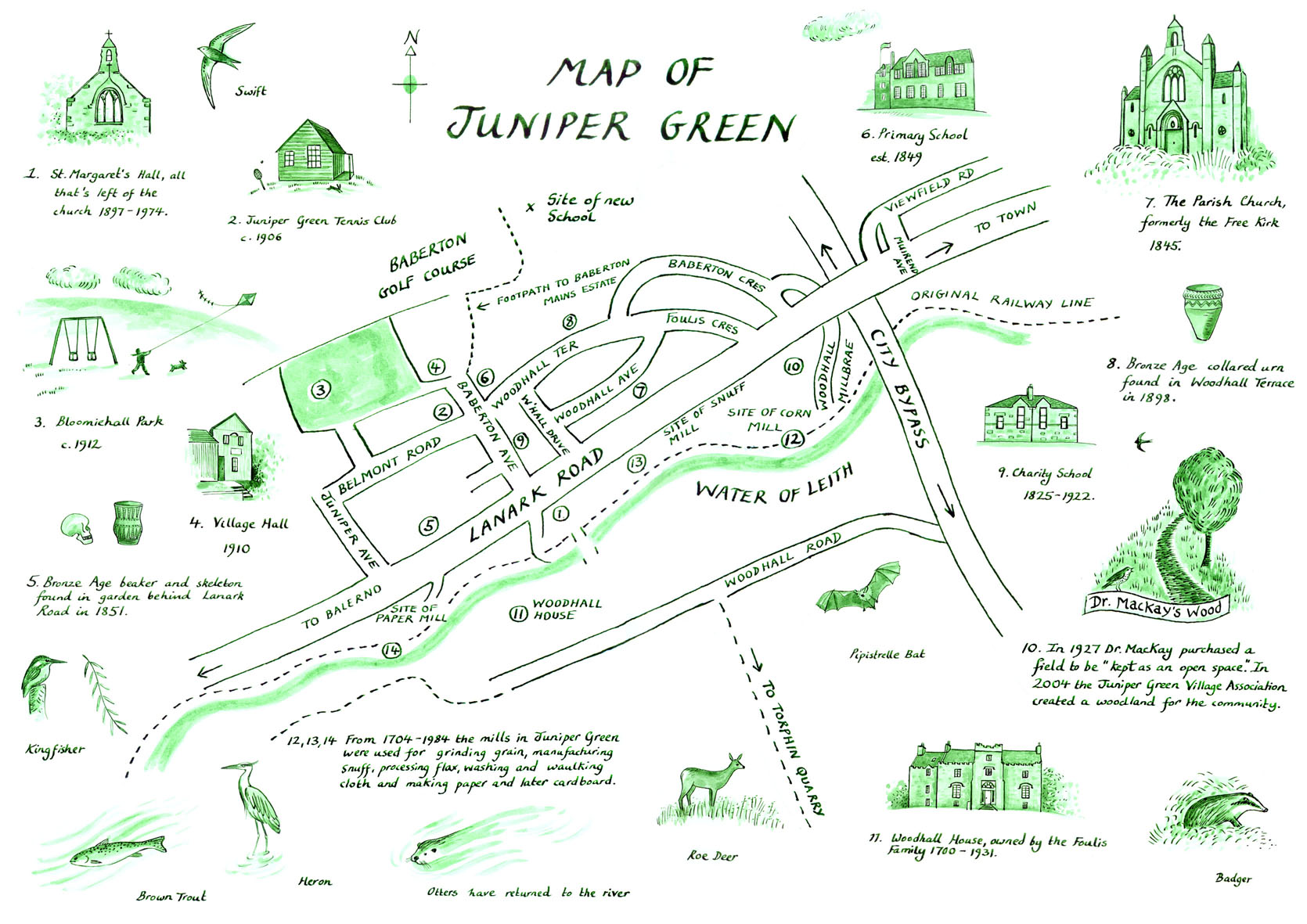
The locations of both of these discoveries are marked on this wonderful map of Juniper Green that was produced as part of the some serious celebrations in 2007 to mark the 300th anniversary of the suburb. Indeed it was this occasion that saw the local community begin to take note of their prehistoric heritage. The map (by Natasha Stewart, part of a leaflet that can be downloaded here) is enlivened by lovely sketches of some of the finds from these sites.
Drawings by Natasha Stewart
As noted, the Juniper Green 300 celebrations were the catalyst for a renewed interest in the history and heritage of this place, and the residents were clearly enthused by the information that there had been a ‘Juniper Green man’ living here 4,000 years previously, to the extent that some of them were able to see his skull up close and personal during a visit to the National Museum of Scotland, hosted by Alison Sheridan. Because as fortune would have it, the skull had recently been scientifically analysed for a major project on Beakers. There is no such thing as coincidence.
Images (c) JG300
This is not the first time that the skull of this male individual, a man of 40-55 years old, has been subject to analysis. It features in the book Crania Britannica: Delineations and Descriptions of the Skulls of the Aboriginal and Early Inhabitants of the British Islands: with Notices of Their Other Remains. This epic trawl of human skulls, phrenology and craniology was published in 1865 so this skull was fairly freshly out of the ground and into the pages of this unnatural selection in short order. The book documents that this was a rounded (brachycephalic) skull, and was unusually heavy and thick-walled.
Image: McTears auction house‘Juniper Green man’ as drawn in Crania Britannica
The principle of this book was very much that humans could be ethnically characterised by the shapes of their skulls, and as the title suggests, a major element of this was to demonstrate the racial superiority of western Europeans as opposed to those who had the misfortune to be colonised by the British Empire. Prehistoric skulls were very much part of this narrative, identifying traits that could be compared across skulls found in the Victorian world. The research and narrative contained within this volume would be best described as ‘scientific racism’, building on the earlier Crania Americana. Researcher James Poskott has noted how important such volumes were in allowing “racist theories [to] gain credibility”.
This is a way of thinking that I thought had been condemned to the prehistory of archaeology but recently I realised that differentiating between skull shapes is still a thing. I noticed that the late Euan Mackie’s 1977 book The Megalith Builders included a reference to skull shapes of Neolithic people and Beaker users as being different, an idea I thought had long since been abandoned. Upon tweeting this I found out that this kind of argument is still being made. For instance in chapter 6 of the 2019 epic Mike Parker Pearson et al. monograph The Beaker People: Isotopes, Mobility and Diet in Prehistoric Britain (Prehistoric Society). I don’t really know what to make of this frankly, but this kind of skull shape data is no longer couched in racist terminology. Nowadays reasons for skull differences are sought in cultural practices such as ‘cradle-boarding’, applied to children to modify skull shape. Indeed Daniel Wilson in his 1863 book The Prehistoric Annals of Scotland (pg 272) suggested this had happened to the Juniper Green man.
The much more recent analysis this skull underwent was part of the Beaker People project, which included radiocarbon dating the head bone, and also carbon, nitrogen, strontium, oxygen and sulphur isotope analysis. This showed that this man (whom Alison called Mr J Green!) had a diet dominated by meat rather than fish. He was probably local and died in the period 2350-2130 cal BC (right at the cusp of the Copper Age and Bronze Age).
The fresh information on these ancient burials was viewed with excitement by local people. At the time of the radiocarbon dating in 2007, then owner of Scott’s Butchers, Colin Hanlon, told The Scotsman, “It’s a huge shock that there were people here all that time ago. The whole community is alive with all this at the moment – everyone’s talking about it. We may arrange something to celebrate that it was here that the village’s oldest resident was found.” There is no doubt that Alison Sheridan played a part in this revival of interest, being described as inspiring by local community group JG Diggers.
There was now momentum. Following on from the 300 year celebration, a monument was erected in the suburb, the one that started this whole thing off for me. In a report on this in The Scotsman on 9th March 2010, this was described as ‘a giant green monument’ (??). This is a slightly confusing description but has some useful detail: “The rectangular monument features carvings of a water wheel, a pot, a skull and a juniper branch, representing aspects of its history” and that it is a “seven-foot structure”. It is not wildly green but made of a greenish slate hence the weird headline. And some of that seven feet is below the ground surface. However what is clear is that the motivation for this was another indication of the sense of pride and awe locally about the depth of time that people had lived in this place.
Local Val Hawkins noted, “so people have been living in Juniper Green since the Bronze Age at least, which was more than 4,000 years ago.” The monument itself was unveiled in front of a crown of 200 people. The standing stone itself – which in effect is what it is – was sculpted by sculptor and stonemason Ian Newton, made of Westmorland slate. The design was by local artist Mick Brettle.
Juniper 300 website images showing the unveiling. Alison Sheridan bottom right
It is located on the corner of Baberton Avenue, Belmont Road and Woodhall Terrace, on a grassy slope beside some tennis courts. I visited this wonderful monument on a chilly December day in 2020, during a slightly lesser set of lockdown restrictions. I was struck by the powerful nature of the carvings on the front side of the stone, the heritage of Juniper Green carved in stone, including the skull that has been mentioned so often in this post and the cinerary urn found in 1898.
The detail on the skull and pottery vessel is wonderful. The skull stares impassively towards the west with a watchful alert eye. The pot has lovely texture on it, decorative strokes and a kinetic form, a suitable vessel made to hold the dead. The 1851 and 1898 discoveries are both shown here together, a tangible symbol of a place with an ancient heritage, conflating time and space into a new symbol for this town at the cusp of the third millennium (AD). From their time to ours. The rear of the standing stone is blank, a canvas upon which the current and next generations might hew their own destinies, document their stories.
This is a fascinating story of a community re-discovering their prehistoric heritage and embracing it. With the enthusiasm and communication skills of Alison Sheridan, this became a potent combination of local pride and – yes – wonder. This is also a celebration of her wonderful and inspiring career, this being only one of many pebbles she has tossed into ponds only to stand back and watch wonderful ripples surge outwards. One need only view her recent Rhind lectures to reflect on a career well spent as not just an academic but also a public prehistorian.
In Juniper Green there was surprise that these jumbled bits and pieces of pots and bone could be so old. Awe that Juniper Green was not just an occupied place for 300 years, or even 3000 years, but 4000 and more. I have it on good authority that enthusiasm remains and Mr J Green’s old head might yet reveal more secrets of who he was and even what he looked like. It reminds me of a great novel I read a few years ago written from the viewpoint of Oliver Cromwell’s decapitated head, Marc Hartzman’s The Embalmed Head of Oliver Cromwell: a memoir (Curious Publications, 2015). This skull has been on a journey since being recovered from the ground, passed through many hands, sat in quite a few boxes and storerooms, and more adventures may well lie ahead.
This is a tale that might be played out in many other towns, villages and suburbs across Scotland which have an equally rich heritage but which await the revelation of deep time to happen. The Juniper Green example shows that prehistory can inspire social gatherings, creative acts, conviviality, and local pride. In this case, the prehistoric story of this place is now available to read online, and traced in the contours of a standing stone barely a decade old.
This is the power of urban prehistory.
Sources and acknowledgements: I am indebted to the work of Alison Sheridan on these discoveries and the clear presentation of those results in the Juniper Green 300 website, which was my main source of information here. Alison also kindly supplied some supplementary information.
Other source used:
Coles, F R. 1899 ‘Notices of the discovery of a cist and urns at Juniper Green, and of a cist at the Cunninghar, Tillicoultry, and of some undescribed cup- marked stones’, Proc Soc Antiq Scot, vol. 33, 1898-9. Page(s): 354-8.
The skull is SK12 in Mike Parker Pearson, Alison Sheridan, Mandy Jay, Andrew Chamberlain, Mike Richards & Jane Evans (2019)The Beaker People: Isotopes, Mobility and Diet in Prehistoric Britain (Prehistoric Society).
The Beaker can be found here (in print, not literally!): Clarke, D L. 1970 Beaker pottery of Great Britain and Ireland, 2v. Cambridge. Page(s): Vol.2, 519, no.1710 and you can view a sketchfab 3D model of the Beaker here.
For anyone interested in some darker research, see Davis and Thurnam, J B and J. 1865 Crania Britannica, 2v. Page(s): Vol.2, vi pl.15. Wash your hands once you are done please.
Isn’t is about time we started to mark the locations of prehistoric sites and discoveries in ways that are visible, informative and accessible to local communities and visitors?
It is factually correct to state that the presence of prehistory in your village, town, suburb and city is not a secret. There are online platforms that can tell you this, such as Canmore in Scotland and Coflein in Wales. However, the information contained in these national (and equivalent regional) databases is encoded in archaeological terminology, while site entries often lack detail, depth and / or images to make the information more accessible to a curious member of the public. They are also portals that currently do not work well on smart phones and depend on decent wifi or 4G, not as available in suburbia as you might think.
One way that would be effective at easing the burden on people finding out this stuff for themselves would be an urban prehistory plaque scheme, my preferred colour being brown, not blue [although I have not tested this colour yet]. This simple device, mirroring schemes in other parts of the UK focusing on famous dead people, is familiar and easy to interact with. In my proposal, urban prehistory locales would be marked with a circular disk a foot in diameter containing just enough information to let curious passers-by know the headline information required. This would be high-level and simple but would contain enough information to (a) demand further investigation and (b) blow minds (at least for some). Digital add-ons may become necessary, but the analogue disks would be a good starting place as my recent guerrilla activity on this front suggests…..
The concept of plaques is a familiar one, but it is not a modern invention. The first scheme was proposed in London in 1866 believe it or not, and is the oldest of its kind in the whole wide world. (If you don’t believe in alien life, its the oldest such scheme in the Universe.) Run by the (Royal) Society of Arts, then London County Council, then Greater London Council, and since 1986, English Heritage, these blue info-circles are London-only although many other local authorities and organisations have since adopted similar schemes. The plaques usually mark a building with a connection to a famous person who has been dead for at least 20 years: ‘the intrinsic aim of English Heritage blue plaques is to celebrate the relationship between people and place’. (There is an excellent online resource, Open Plaques, which curates images, locations and stories of plaques from all over the place, well worth checking out.)
There is something immediate and accessible about plaques. They are spatially situated in the correct location someone famous lived and / or died (and less often, where events of note took place or an earlier building once stood). They are reassuringly analogue and do not depend on wifi or a mobile signal although this does not preclude follow-up research later. In some cases, they can surprise and even delight, as when I completely accidentally stumbled upon this Wheeler blue plaque when I was heading for a Cochno Stone meeting in London a couple of years ago.
But can we do more with plaques than just celebrate the rich, famous, mostly men? Could plaques be used to tell stories of what happened in a place, rather than simply who resided where and when? And can we push this back deep into prehistory?
Mike Pitts made a strong case (in the July-August 2012 British Archaeology magazine) for a plaque scheme that does not simply focus on famous recent people such as archaeologists and antiquaries, but also the dead found on excavations. (‘Let’s celebrate the anonymous people who made Britain’ is the sentiment, although I’m not so convinced by this jingoistic tone.) Nonetheless, this is a well-argued polemic and was accompanied by the mocking up of ‘Ochre plaques’ as he called them, in each case located where a ‘famous’ prehistoric dead person had been found…
Ochre ‘urban prehistory’ plaques, all images reproduced courtesy of Mike Pitts and British Archaeology.
These are very effective, and got some good feedback at the time and also when Mike recently re-posted them on twitter in response to my own musings on the subject. The focus here on the famous dead fits in with the broader aspirations of plaque schemes although in truth even the ancient dead whom we give nicknames are still unknown, while in some other cases multiple burials and events might also be plaque-marked.
A good example of how this might work is this surprisingly detailed plaque that is situated in a car park in Christchurch, Dorset.
Christchurch. Image reproduced courtesy of Annie-Leigh Campbell
This is part of a local HLF-funded ‘unofficial blue plaque’ scheme, the Millennium Trail, of which are there are many across England and indeed beyond. This series of plaques is accompanied by a map and leaflet available locally.
In the spirit of experimentation I recently carried out a couple of field visits to urban prehistory sites – plaque attacks! – having prepared in advance a rather low tech and mocked up plaque for the occasion. I confess I used dark blue for these early experiments, to provoke a reaction by subverting the familiar format, but will, like a judo person, aim to step up to brown in the future.
My two case-studies are in a sense classic urban prehistory sites – Bronze Age burials that were found during urban expansion in the form of road building, and were subsequently destroyed (although in very different circumstances). Importantly, in neither case is the location of this discovery marked in any way, almost nothing is known about the sites, and in at least one instance the nearest resident was completely unaware of the story. These are unremarkable urban streets with a hidden, remarkable secret, that if known might change the way that (some) people view the place that they live, but hopefully not in an Amityville Horror type of way.
Succoth Place, Edinburgh
In May 1901, during the construction of a new road to the west of the city centre, Succoth Place, running off Garscube Terrace, workmen came across a stone cist that contained a fine prehistoric urn. This was taken into the care of the architect D Menzies and then collected a few days later by archaeologist Fred Coles who subsequently helped investigate the site and wrote up a brief excavation report. The urn was recovered from the cist by the foreman after the cap stones had been broken to make way for the pavement kerb. Further damage to the cist itself revealed, remarkably, that this was a rare double-compartment cist, with two burial cells separated by a single upright central slab. Coles assisted with clearing out the second chamber, within which was a second urn. Both are what we would term Food Vessels and belong to the early Bronze Age.
Nothing else was found in either cist compartment, other than ‘minute fragments of bone, which, on the gentlest handling, crumbled away’. An undignified and dusty end.
Both Food Vessels were later accessioned to the National Museum, and that was the end of the whole business, with presumably the remnants of the cist being wrecked to allow road-building to continue, the whole site having been excavated in a rather crude fashion which was the norm for that time.
In early May 2018, almost exactly 117 years after this discovery, I visited Succoth Place with Glasgow PhD student Denise Telford in the rain armed with my cardboard urban prehistory plaque.
As ever with such trips, careful planning was required, and the friend of the urban prehistorian, the ragged annotated folded A-Z, was employed to get us there safely and efficiently.
The leafy suburbs of this part of Edinburgh, near the Water of Leith, looked rather dreich in the downpour, and we sheltered under overhanging vegetation from time to time as we wound our way up to the top of a hill (via Garscube Terrace) crowned with massive lavish sandstone mansions and a private school. The friendly lollipop man helped us across Henderland Road, just in case we should be crushed by a massive 4×4.
We reached the Garscube and Succoth soon enough. Despite the distinguished and peaceful surrounds, subversion was evident: the street sign has a runic addition in tiny letters, creating the memorably Shakespearean phrase Succoth My Nob Pl(ease).
Coles recorded that the cist was found 60 feet from the junction and so we headed there, with the location where the Bronze Age dead had once lain being mercifully free of the indignity of parked cars.
There was nothing here to mark this burial place, and I am fairly sure that the inhabitants of the big houses here know nothing of this either. There was nothing left to do but mark the place with the plaque, which had been carried here in an old-school 5p Morrison’s carrier bag for protection from the incessant rain. In error, Denise snapped 118 photos of me holding the plaque of which the best one is reproduced below.
There was little sense that this was anything other than a posh suburb and certainly there was no room for the remembrance of the dead – the dead whose bodily remains crumbled to dust in order for sandstone mansions to be reachable by horse and cart in as much comfort as was possible at the time. Let’s not be emotive and say that this part of the city was built on the (tiny) bones of the dead, but it was, and perhaps this needs to be remembered, out of respect for the deceased, who did not even have the dignity of a ghostly presence or their own plaque. Until now.
As John Mahoney’s character in the movie Barton Fink so memorably implored drunkenly: ‘Honey, where’s my honey?’.
Morar Road, Crossford, nr Dunfermline
Let’s travel to Fife, just across the River Forth from Succoth and all that, to the location of another Bronze Age urban cist that was knackered in order to facilitate urban expansion. In this case, the cist was destroyed before an archaeologist was even able to look at it – and this happened in 1973!!
During construction of roads for a new housing estate called Keavil on the south side of the town of Crossford on 13th November 1973, a stone coffin or cist was found. The workers on this construction project thought that the collection of flat slabs was ‘some sort of old land drain’ and destroyed the structure to make way for the road the next day. A Mr A Hall was able to recover one thing from this burial, a fine complete Food Vessel pot, which suggests that the destruction of the cist was perhaps not as cavalier as reported, and perhaps the workers could have stopped when this was found rather than when it was all too late. So much for rescue archaeology.
A sober note was made of this unfortunate event in that year’s Discovery and Excavation in Scotland, while a drawing of the vessel and a brief accompanying narrative was published as an addendum to the excavation report of a cist cemetery found at Aberdour Road, Dunfermline (a site I blogged about back in 2012).
The contractors on this build, Geo Wimpey and Co, ‘kindly’ handed the Food Vessel over to the local museum and got on with making roads and money.
Armed with this sorry story, preparations for my second plaque attack were formed a week after the Succoth escapade. Using my time-honoured cheapo approach I created a similar plaque to the previous effort but this time with amended and simplified my logo. I had to contend with a greasy stain on the cardboard transferred from a kitchen surface the work was carried out on.
I visited this location with Glasgow PhD student Andrew Watson, on the way back from another urban prehistory-related fieldtrip to Fife. Andrew map-read me into the estate via a series of colourful streets (none of them Cist Street which might have been the least Wimpey could have done): Hunt Place, Katrine Drive, Western Avenue and then Morar Road and Affric Way, together representing a confusing mixture of street types for no discernible reason. And then we were there, in a quiet suburban road lined with blue bins and puddles.
The kind of place where twenty is plenty.
Andrew and I quickly set up a sophisticated photo shoot, marking the location that the cist was found and destroyed, 1m below the current road level, in a memorable fashion.
As we struggled to get to grips with the placelessness of this place that had once been a sacred burial spot that must have had an abundance of place, the owner of the house outside which we were messing about came out to see what us ‘boys’ were up to. We explained out business and he was amazed that such a thing had been found outside his house, as it was being built, and he assured us he would tell every visitor this exciting revelation (although he also said he hardly got any visitors so this may not be a strong method of dissemination). He declined the chance to have the plaque (an original and unique piece of art one might argue) hung on the front of his house however.
Knowledge exchanged, he walked back inside, and by god I think he had a spring in his step.
This sobering encounter with an old man ended our photo session, and I must say I don’t think Andrew was taking this as seriously as he could have been.
Plaque attack!
The cardboard plaques that I have made and taken to places that hold rich prehistoric secrets is a device that has started conversations and created complex experiences for all involved. These places of death and burial remain unmarked although digitally their story has now been told again, perhaps for the first time in decades or more, and this is how such plaques could act as easy gateway drugs into the hard stuff of prehistory.
Truth be told, we cannot just expect people to find out about the prehistoric events that may or may not have taken place when their houses or schools or roads were being built or improved. We – archaeologists, heritage professionals – need to be evangelical about this, pro-active prehistory-pushers, talking to people and braving the rain to find ways that tell the lost stories of ancient bones and bits of pottery. Circular information panels may or may not be the best way to do this, but we have nothing to lose by trying to follow the advise of Mike Pitts.
Let’s celebrate the ancient dead as well as the modern rich and famous. Let’s tell stories of deep time, generate wonder and surprise, and change the way that people see the places that they live.
I wonder – where will the next plaque attack be?
Sources and acknowledgements: I would firstly like to thank Denise and Andrew for accompanying me on these fool’s errands that I do from time to time, and for the stimulating conversation both provided; there ideas have filtered into this post. Thanks also to Mike Pitts for allowing me to use images, and drawing on his own ideas; please join the Council for British Archaeology if you want to receive regular copies of British Archaeology magazine. Thanks also to the many positive comments I got about the UP plaques on twitter.
The report on the Succoth Place discovery can be found in a paper by Fred Coles, ‘Notice on the discovery of cists containing urns at Succoth Place, near Garscube Terrace, Edinburgh’. This was published in the Proceedings of the Society of Antiquaries of Scotland volume 36 (1901-02). The Food Vessel and cist image in the post above were both sourced from that paper.
For information (limited) on the Morar Road cist site, see pages 130-1 of Close-Brooks, Norgate and Ritchie (1974) ‘A Bronze Age cemetery at Aberdour Road, Dunfermline, Fife’, Proceedings of the Society of Antiquaries of Scotland volume 104. This was also the source of the pot drawing for this site. This journal is open access.
The Christchurch blue plaque was first posted on twitter by Annie-Leigh Campbell, while the map / booklet image related to the Millennium Trail in this town came from a website called Dorset Visual Guide. The quote about the purpose of the London blue plaques near the start of the post comes from the official EH site about them, linked to in the same paragraph.
Some urban prehistory sites are strange. Some are sad. Some are both.
There is something melancholy about a prehistoric site that has been destroyed with nothing done to compensate. We are now used to the fairly cosy arrangement that we can accept the destruction of archaeological sites in exchange for them being professionally and fully excavated. This is a deal that archaeologists – and society without most being aware of it – have made with the free market economy. We won’t interfere too much with endless development, change and economic progress and the juggernaut won’t completely flatten what is left of the past without first slowing down a bit or taking little detours. The result is jobs in the heritage sector, lots of random data we would otherwise not have, and sometimes local communities benefit from these transactions too. This might be a Faustian pact, it might even be entirely sensible, but it does mean that in 2017 one of the most important and uncontrollable ways we have of finding prehistoric sites and sucking the information out of them is driven by social need for, and the political demands of, development.
But in the nineteenth century when society was still getting to grips with the implications of massive scale urban and industrial expansion, railway line and canal building, and the requirement for the extraction of the necessary aggregates to make these things happen, no such deal existed. Archaeological sites were swept aside simply because they were literally the wrong place at the wrong time. And so inconvenient standing stones were toppled, or ”blown with powder’ as in the case of a stone circle at St Colmac’s, Bute. To add insult to injury, whatever survived these extractions was then put to use as building materials, built into walls and barns, or broken up and utilized serendipitously and randomly e.g. in road and rail foundations. Stone cists and coffins were emptied of their contents, with much of the goodies inside ending up on the mantelpieces of the rich landowner, local vicar or an eccentric antiquarian, soon to be ‘lost’. Of course, this was all underpinned by money as well – but the power relationship was balanced differently than it is now. Archaeological sites could be swept away on a whim, facilitated by the signing of a cheque (one of those big fancy Victorian ones), and the data and information that resulted from any crude interventions that followed could be characterized as limited, selective and often rubbish.
Whoever said that no deal was better than a bad deal?
A dead megalithic monument in Clackmannanshire prompted these thoughts to be re-articulated once again. It is a sad and strange story that represent the ways that even substantial prehistoric monuments, when competing with the demands of nineteenth century economic requirements and the requirements of the landed gentry could come to a very sticky end, reduced to nothing more than an antiquity map symbol.
I have a Cunninghar plan
The site to which I refer was called Cunninghar in Tillicoultry. This is a monument that according to varied accounts was substantial, consisting of a circular or oval setting between 20m and 35m in diameter of standing stones three feet high at the foot of the Ochils. (A bank apparently surrounded this, suggesting to me this was a kerb cairn rather than a stone circle for what it is worth.) No record of the number of stones survives, nor any etchings or drawings of this monument. The enthusiastic recorder of prehistoric lost causes and megalithic wild goose chases, Fred Coles, tried to get to the bottom of the story of this stone circle right at the end of the nineteenth century, his sources of information patched together from conversations with an experienced local forester, an OS Name Book entry and some nifty mapwork.
His informant, the estate forester, gave a vivid description of the stone circle and the fate that it met (for the source of this quote, see the end of this post; Location A is shown on Cole’s map reproduced below):
The rather undignified evisceration and re-purposing of the monument by the local gentry for their own grand designs, and also perhaps with one eye on the quarrying and thus financial potential of this location to come, left the bank and one single standing stone on site, which became the focus of excavations in the 1890s when two cists, one containing a fine Food Vessel, were discovered on site as the ridge was gradually denuded for aggregate extraction. The account of these discoveries was documented fastidiously by R Robertson in a paper written slightly before Coles arrived on the scene, and in his observation that the site was situated on an ‘elevated ridge of sand intermixed with gravel’ lies the seeds its downfall at the hands of quarrying for those materials.
There is no need to rehearse the details here of the discoveries that occurred in harmony with the rhythm of the extension of the gravel quarry, surprising extractions, suffice it to say that several Bronze Age pots, and a stone marked with rock-art, were discovered.
My favourite detail of these impromptu rescue excavations was the discovery by Robertson in the location within a cist that one would have expected a head to be located, ‘a quantity of a fibrous or hairy substance, of dark-red colour’. Analysis was undertaken of this mysterious material by a Professor Struthers who appears to have been something of an expert in these matters, having his own collection of ancient hairs which he sometimes exhibited to the public. He concluded, by comparison with his own reference collection, that this was not the hair of a man, ox or horse – but it might have been the ‘wool’ of a fox, dog or rabbit. (Audrey Henshall later suggested it was otter.) No further analysis of this was undertaken but I like to imagine this was the remnants of a crazy stoat hat. (It is worth noting also that the name of this site derives from something to do with rabbits suggesting this is the kind of location where a rabbit might have burrowed into a cist by accident and died in there. Just saying.)
Fred Coles reported on another cist found here a few years later, although had nothing to say on the matter of the ginger-haired deposit. He also noted that quarrying had not begun at the south end of this ridge by the time of the OS 1st edition mapping of the 1860s, but by then, the stone circle was already gone, for the reasons already noted above. The sand pit to the north suggests the landowner was well aware of the potential value of this location and the pesky stone circle that was on the way of his bank account being further bloated.
OS 1866
Later maps show the outline of the quarrying in more detail, and so show the activities that led to the discovery of Bronze Age burials here as well as completely removing the site where the stone circle / kerb cairn. In a sense the quarrying was more destructive than the standing stone removal, in the same way as extracting one’s teeth is not half as bad as losing your mouth.
This megalith was wiped off the map, and it was on maps that ironically was the only place where it continued to exist.
OS 1951
Gradually, this location became increasingly surrounded by housing estates and the trappings of the modern urban landscape. Using a really helpful map that Coles made of the archaeological discoveries at Cunninghar, and subsequent mapping, it is possible to roughly plot where these key discoveries were made in relation to the modern Tillicoultry – sandwiched between Dollar Road and Sandy Knowe with a fine view over a cemetery and war memorial.
It was no surprise to me when I visited on a quiet Saturday morning that there is no sense whatsoever that in this corner of Tillicoultry once stood a substantial multi-phase Bronze Age monument. The Cunninghar sand and gravel ridge that so attracted quarriers survives within the urban setting, in the form of a wide grass-covered bank that runs north-south between two housing estates. A path runs along this ridge and I mounted it, from my parking position on the appropriately named Sandy Knowe, via a set of steps. Once on the embankment I followed a rough path that lead to a broader and uneven overgrown area with a mast atop it. This metallic tower stood within a steel cage with warning signs adorning it.
This area betrays little to nothing of its former purpose, other than that it is possible to imagine this as a prominent viewing point with views down to the River Devon. The ridge came to a sudden end at a wall on the fringe the A91, while an escarpment topped with a feeble fence which meandered from east – west marked the limit of the sand and gravel quarry that was once here that finally removed the remnants of this monument, the conclusion of a slow-motion series of interventions.
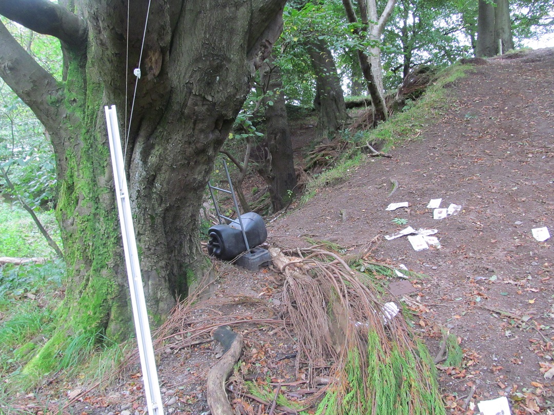
As I wandered around in the faint hope of seeing something, anything, that might hint at megaliths, burials or an embankment, I noticed a large stone lying on the other side of the fence on the edge of what was once the quarry. This had previously been identified by the Northern Antiquarian as being a remnant from the stone circle, and although it seemed to me too small to have fulfilled this purpose, it did look out of place and may once have been a prehistoric something or other.
Down I went into the quarry, now an overgrown edgeland betwixt road, mound and back gardens, nothing but weeds and rubbish strewn about. Spatially, if not physically, there had been a stone circle here once, perhaps elevated 5m above my head. But all that remained were random sad objects: a twisted child’s car seat, a hoard of charity shop sacks and the splayed and stretched out tendons of a Venetian blind.
This made me melancholy. A stone circle had been lost – so be it. But it had been lost and not adequately compensated for. A Food Vessel, Urn and a clump of dead rabbit / otter had been added to the archaeological record, dots on a distribution map (except for the rabbit unless there is a distribution map of Bronze Age wigs), but we don’t even know how many megaliths once stood here. Tillicoultry House with its amazing standing stone lined drain was demolished around 1960, another victim of progress, while the current location of the rock-art-marked stone, visited and visible to Ronald Morris in 1966, is unknown. The Food Vessel is held in the collections of the National Museum of Scotland.
There is nothing to let people whose houses are literally metres from where a prehistoric centre of ritual, ceremony and burial once stood know about this, no noticeboards that might inform casual passers-by, a lack of an app or virtual reality ancient version of this place to download. This monument has gone, a victim of all sorts of Victorian hoo-ha. And not only was the monument destroyed, but the place where this monument once stood was destroyed, atomically removed. Once it was removed, the megalith was split up into pieces and then it was later destroyed again, a second death. The burials that were left behind were recovered to an extent, but are now hopelessly dispersed.
There was no deal here – this was a hard extraction, and once the stones had fallen from this cliff edge there was no going back.
I have often said in the past that urban prehistory is not about a sense of loss, or sadness, and this is still the case. But for Cunninghar there have only been bad outcomes, as bad as it gets, and it seems a hopeless case, all that remains being this sad story and footnote in the National Monuments Record of Scotland.
Melancholy is not the same thing as sadness, nor is regret. What I regret about some urban prehistoric sites is that their destruction was in vain, the price paid too high.
Prehistorica melancholia.
Sources and acknowledgements: This post benefited from many conversations with Helen Green about heritage, development and compensatory measures (or lack thereof).
Little has been published on Cunninghar, or the variants of spelling of that name that are out there (Cuninghar, Cunningar). Two articles were published in close succession in the Proceedings of the Society of Antiquaries of Scotland about this site, both referred to above. The first of these was Robertson’s 1895 effort, ‘Notice of the discovery of a stone cist and urns at the Cuninghar, Tillicoultry’, in volume 29; the second Cole’s 1899 ‘Notices of the discovery of a cist and urns at Juniper Green, and of a cist at the Cunninghar, Tillicoultry, and of some undescribed cup- marked stones’ (volume 33). Both can be read online for free via the Society webpage. The image of the Food Vessel came from the Robertson paper, the cist plan and rock-art ‘photo’ from Coles, and the latter also provided the quote near the start of the post.
As we drive across a motorway intersection, through the elaborately signalled landscape that seems to anticipate every possible hazard, we glimpse triangles of waste ground screened off by a steep embankment. What would happen it, by some freak mischance, we suffered a blow-out and plunged over the guard-rail onto a forgotten island of rubble and weeds, out of sight of the surveillance cameras? [JB Ballard, Introduction to Concrete Island]
The perceived wisdom is that it is not a good thing to always be under the flight path of an international airport.
Or adjacent to a busy motorway intersection.
Although I suspect this was a state of affairs that would have please JG Ballard with his Shepperton home.
But that is the fate of one of the strangest and least understood prehistoric monuments in central Scotland – Huly Hill, located in the village of Newbridge just to the west of Edinburgh.
The monument sits right beside a busy road intersection, where the M9 and M8 motorways meets, along with the A8 and the A89. There is a small service area just to the south of the Huly Hill which includes a petrol station and a MacDonald’s. Industrial units abound. Just to the north are a series of luxury car showrooms.
Like the protagonist in Ballard’s Concrete Island, Maitland, this monument is trapped amidst the infrastructure of the car. But with added airplane noise. And the central conceit of that novel has strange parallels with Huly Hill: by stumbling off the motorway, it is possible to become marooned in a very different kind of place, an enclosure with its own rules, temporality and ruins.
The close proximity of multiple roads and places for purchasing Mercedes motorcars is not the only way that Huly Hill has become entangled with cars. A much more violent encounter has been recorded in this online account, an incident in 2001 where an attempt was made to drive a vehicle across the central barrow.
(c) Cairnpapple Archaeological Research Association (CARA)
This shocking act of violation would have, one imagines, resulted in smashed front wings, bent bumpers, a twisted bonnet and climaxed with radiator fluid spilling all over the earthy lip of the mound – a megalith-motorcar mounting.
Around the same time a burnt out vehicle was dumped beside the standing stones, a sacrifice to some insane pagan car god, cremated and melted and tagged, offered in mitigation for the scarification of the burial mound.
(c) CARA
The constant hum of cars all around, and the frequent roar of steeply banking planes overhead, is a product of the gradual wrapping of the site within the trappings of modern transport infrastructure and urbanisation over the past 100 years.
Yet it was not always like this.
In fact, Huly Hill (NT17SW 8) is a remarkable monument which surprisingly little is known about consisting of a setting of three standing stones, with a circular barrow or cairn off-set within this stone setting. It was described in the Statistical Account of 1794 as ‘circular mound of earth’ with surrounding standing stones, and in the 19th century was known locally as The Heelie Hill. Crude investigations by Daniel Wilson into the centre of the cairn in 1830 apparently revealed only ‘a bronze daggerblade, a heap of animal charcoal, and small fragments of bones’. Fred Coles carried out a ‘survey’ of the monument in 1899, and was unable to ascertain the true extent or location of this excavation, or the fate of the contents found therein.
Fred Coles’ 1899 survey of the standing stones
At the time of his visit, the monument still had a rural setting, and Coles offers this detailed account of his visit:
The Heelie Hill, as this Cairn is locally called, can easily be reached by taking the first turn to the left after quitting the train at Ratho station on its north side. As one walks westwards, the first object to arrest the eye of the antiquary is a great monolith, over 9 feet in height, in a field close to Lochend farm.
He noted that the standing stones and round mound did not appear to relate to one another concentrically, and produced a very useful survey plan to make this point.
The plan of Huly Hull drawn by Fred Coles, with a section through the central cairn / barrow
Coles also mentioned in his description of the mound the presence of a low wall surrounding its base, which most certainly was not prehistoric and so may have been an addition to the monument after Wilson’s poking about, or some other form of landscaping / tidying up.
Thereafter, there is little sense of any attempts by archaeologists to understand this site further, with two geophysical surveys, one in the 1970s and one in the 2000s, failing to add anything else to our knowledge of Huly Hill other than to confirm there does not appear to have been a more populous stone circle in this location or a ditch surrounding it. We do not even know what it was that Wilson found: a dagger, or spearhead have both been suggested. But it likely that this was a Bronze Age burial mound with attendant standing stones, which may have been earlier components of the complex.
Not that any of this meager information is available to local people or casual visitors. A noticeboard that introduced the site that once stood here was removed many years ago.
Missing information board. Missed opportunity.
It is clear is that urbanisation and modern infrastructure began to envelope this monument as the twentieth century went on. This is indicated by the gradual increase in size of Newbridge shown across the 1st and 2nd edition OS 6 inch maps. (These maps also show nearby railway lines and a main Glasgow – Edinburgh road, so this has not been a quiet place for quite some time….)
1853
1893
1955
A new chapter of the biography of Huly Hill was metaphorically written when it found itself under the flight path of Edinburgh airport. This airport started life as a military base in 1916 before becoming a commercial airport in 1947 although initially flights over the prehistoric monument would not have been frequent. However, located about 500 m to the WSW of the main runway at Edinburgh, Huly Hill has planes flying low over it either taking off, or landing, depending on the prevailing wind, what seems like every few minutes.
As well as the airport expansion, the Newbridge junction next to Huly Hill has expanded several times in the past few decades, as a major hub in the motorway network, where the M8 and M9 meet. The junction here was first established in 1970 around the same time the motorways were opened, and underwent a massive expansion in 1997 to accommodate the sheer volume of traffic.
Edinburgh Airport viewed from the west, with the Newbridge Junction bottom centre. Huly Hill is just out of shot.
Therefore, this ancient, prehistoric ceremonial and burial monument is being crowded out by the trappings of the modern world, in the middle of a vortex of fast-paced and loud commuters, wrapped by noise and neon lights. It seems so far removed from the rural location that this must once have been that it takes an effort of will to imagine what this monument might once have been like: a place of death and memory. Now it is place of lorries, fast food wrappers and paint.
There have been other modern interactions too. Last year I visited Huly Hill to find a group of travellers had moved into the space between the central barrow and one of the standing stones. The caravans and four wheel drives made a car park of the monument, and I was threatened by one of the inhabitants when I tried to take photos of planes flying over the site. There was clearly also tension amongst the locals about this development, although when I passed a few weeks later, the site had been cleared, and another transient phase in the life of Huly Hill was over.The ebb and flow of urban life continues, regulated by the needs of our consumerist and consuming society. Yet who is consuming Haly Hill?
The settlement of Newbridge is just to west of Edinburgh Airport, offering great views of incoming aircraft and access to the M8 and M9.
No mention of the prehistoric cairn or the three standing stones that sit in a green space within this village. Only the proximity to ways and means to leave the place, or the opportunity to watch machines of mass transport go by.
In Concrete Island, all that Maitland can do with a growing sense of futility and frustration is watch cars go flying by, their drivers staring at the road ahead and paying no attention whatsoever to an increasingly dishevelled character waiving at them for help.
I don’t usually bemoan the state of urban prehistoric sites. I am all about positivity, about seeing the potential in places with deep-time regardless of the inherent rubbishness of some of them, and about accepting changes that happen to what we blithely call the archaeological record as being the normal way of things since prehistory. However, Huly Hill does trouble me.
This is a monument in a prime location: thousands of drivers and passengers must see it every day from the luxurious viewing position of their cars. It has a local urban population, some of whom walk past the standing stones and barrow frequently. It is right next to a busy bus stop and clearly visible from the McDonald’s restaurant across the road. Even a casual glance up while pumping fuel will allow drivers to catch a glimpse of a standing stone or two. Airplane pilots and co-pilots see it frequently, and maybe some passengers grab a glance as well. This must be one of the most visible prehistoric monuments in Britain.
Yet as archaeologists what have we done to tell people about this monument, encourage visitors, protect it against further decline and in general used it for the common good?
Nothing.
It is a partially re-instated mound with a modern-ish wall around it. The standing stones may or may not be in their original locations. A new noticeboard and some signs would cost money. There are roads and cars and lorries and noise all around. The landscape context has been compromised. It is under the flight path….. I can hear all the excuses now.
But actually, how much time and effort would it be to raise awareness of Huly Hill and do interesting things there?
I’ll just need to do something and find out.
He had now gone beyond exhaustion and hunger to a state where the laws of physiology, the body’s economy of needs and responses, had been suspended. He listened to the traffic, his eye on the red disc of the sun sinking behind the apartment blocks. The glass curtain-walling was jewelled by the light. The roar of the traffic seemed to come from the sun (JG Ballard, Concrete Island).
If R really did mark the spot beneath the tarmac – beneath the car park – where Richard III was found….
….then what might be find beneath the tarmac elsewhere….
….beneath our feet and our traffic and our infrastructure?
The ancient dead also endure…..
….beneath our cities, our towns, our houses, our gardens and our car parks.
Note: Cremation Urn (noun): a ceramic vessel, typically dating to the Bronze Age, used for the collection and storage of cremated human remains. The cremated bones were often sealed inside these large bucket-shaped pots by a skin or hide lid. Cremation urns were generally buried in pits, often upside down. The majority of Bronze Age cremation cemeteries found in the 20th century were uncovered due to urban expansion and road building.
Source: the Richard III photo was sourced from the Bailiwick Express.
Fragments of a site, documented poorly, beyond living memory. The excavation of a Bronze Age cist cemetery in a sand pit on the south-west fringe of Glasgow in 1928. By Ludovic Mann, who else? Piecing together the pieces, re-telling the story, making sense of it all. All we are left with: fragments, pots, photos, rumour, myth, mystery. Only fragments of a site, material clues, things, both familiar and unfamiliar. Found in a sand pit on a ridge beside Mount Vernon: a place now a quarry and landfill site. Fragments. That’s all we have. As archaeologists, as (pre)historians of Glasgow, the voice of the past drowned out by the quarry machine, the truck, the motorway. The quarry and the cemetery. The cemetery and the quarry. The cemetery in the quarry. The quarry on the cemetery.
Green-oak-hill
Brown-sand-ridge
Mount Vernon.
Windy Edge.
Fragments of a site, documented poorly, all we are left with.
discovered a complete Bronze Age skeleton in splendid condition
when carrying out excavations recently
on a sandy hillock at Mount Vernon near Glasgow
the skeleton is about 4000 years old
and it is quite possible
that a number of others may be found in the vicinity
as it was the practice of the people of that age
to have tribal burying grounds
over which they raised cairns.
The discovery was made
at a [sand pit] worked
by the Greenoakhill Sand Company.
Until recently
a mansion-house which was built 130 years ago stood near the spot
and it is thought [that] the cairn raised
over the tomb
was demolished when the ground was being cleared to [make] a garden for the mansion.
When some workmen were removing sand
from the hillock
an earthenware vessel of beautiful design
rolled out of a cavity constructed of slabs of stone
the find was at once reported to Mann
who went out and started systematic excavations.
Found three feet below the level of the grass a walled chamber 3 feet 3 inches by 2 feet the sides of which were built of vertical red sandstone slabs as a rule these tombs have a solid stone cover but in this case the covering consisted of about [X] rounded stones carefully packed over the skeleton.
Above these stones
was a handful of bones
which it is thought had been food intended for the dead
but this matter will have to be more carefully investigated.
When the black earth and boulders were removed
there was discovered a skeleton
carefully placed in position facing south-east
exactly along the medial line of the structure
the head was that of the brachycephalic or round-headed type
usually associated with the Bronze Age.
According to the fashion of the time
bodies were some[times] cremated
and the reason why
some bodies were disposed of in this way
while others were simply buried in the usual manner
puzzles archaeologists.
Beside the skeleton was a vessel of earthenware,
in which it was the practice to place food to sustain the spirit
on its journey to
the other world.
Food Vessel from Greenoakhill, held in Glasgow Museums collection, who hold the copyright for this image
Ludovic Mann and assorted suited visitors – dead and alive – antiquarians and magistrates – at Greenoakhill (c) Glasgow Museums
Attempt at an Inventory of the Material, Sediment and Human Deposits Excavated by Ludovic Mann at Greenoakhill in the Course of the Year Nineteen Hundred and Twenty-Eight
Six Food Vessels, two pottery bowls.
Five cists, one wooden coffin
One crouched inhumation of an elderly man, one crouched inhumation of a young woman, one crouched inhumation of an adolescent, one fragmentary inhumation, two skeletons, one cremation deposit.
One flint arrowhead, two flint knives, one white pebble, one hair moss garment.
A place of restricted access. A gated community. Movement within mediated by fences, signs, barriers. Specialised and highly regulated clothing needs to be worn to secure entry to the scene. For your own safety. And the safety of others.
A Bronze Age cemetery? Or a modern industrial quarry?
Both.
The cemetery and the quarry, both places of danger, of transformation, places we need protection from, locations and activities that need to be contained.
The wearing of special safety gear is compulsory. Without exception. PPE. Personal Protective Equipment.
Personal Protective Equipment. Sealed off from danger. Wrapped up for safety. Clearly marked out from the others. Distinctive. Safe. Because these are taboo places. The quarry and the cemetery. The cemetery and the quarry. Places where digging into the ground is an act of devotion, an act of conviction, a dangerous and troubling activity, hidden away from the others.
Things happen here that have to be taken seriously and carried out appropriately, according to the rules and regulations.
And access has to be mediated by key individuals – gatekeeper, shaman, foreman, security guards, man in a wee wooden shed.
To enter the inner sanctum.
KEEP OUT. TRESPASSERS ON SITE WILL BE PROSECUTED.
DANGER. QUARRY WORKINGS.
NO ENTRY. DANGER!! PLACE OF DEATH.
Because the quarry and the cemetery are both polluted places. They have depth, they have power, and they are repositories of value and potential energy, derived from underground. Social capital. They are connected places, entangled across and beyond the societies from within which they emerged: Pastoralism / Capitalism. Entangled in networks of meaning that expand beyond this geographical location and its enforced boundaries, beyond the knowledge of any one individual visiting a grave, laying the dead to rest, driving a truck, reading the Daily Record in a cab. Exploded places, shrunk down to just this one place, a dot on a map, a high point, a special place, a pit. The quarry and the cemetery.
During the daylight hours: the traffic in and out of this place is incessant, unrelenting, tireless. It never stops. Back and forth, in and out, a hive of activity, of noise and light. It never seems to end.
By night, it is silent and dead. It reeks of death, of waste, of subterranean detritus. Landfill. Burying the very things and bodies of a community. Murmurations of crows and ravens and blackbirds fly overhead. There is a miasma. A stench. The long dead and their ancient bones. The assorted containers buried and put beyond use: Food Vessels and food vessels, Beakers and beakers, skulls and rusted beer cans. Encased in a shroud of stone and earth and grass. Put in a stone box. Fenced off.
A place of restricted access. A gated community. Movement within mediated by fences, signs, barriers. Specialised and highly regulated clothing needs to be worn to secure entry to the scene. For your own safety. And the safety of others.
A Bronze Age cemetery? Or a modern industrial quarry?
The quarry and the cemetery. The cemetery and the quarry. The quarry on the cemetery. The cemetery in the quarry. The quarry on the cemetery.
Neither one nor the other. Both.
The location of the cemetery today
Sources and acknowledgements: each element of the tripartite structure of this post depended on different sources and inspiration. Image credits are in captions; those with Glasgow Museums copyright came from The Glasgow Story website.
Complete Skeleton. Find Near Glasgow. A poem. The entire ‘poem’ is a very slightly adapted version of a newspaper story about the excavations that appeared in the Glasgow Herald on 27th July 1928.
Attempt at an Inventory of the Material, Sediment and Human Deposits Excavated by Ludovic Mann at Greenoakhill in the Course of the Year Nineteen Hundred and Twenty-Eight. The data contained in this inventory was derived from a summary of the discoveries that can be found in the CANMORE entry for this site. The site has NMRS number NS66SE 2. The title for this short section owes much to the Georges Perec piece ‘Attempt at an Inventory of the Liquid and Solid Foodstuffs Ingurgitated by Me in the Course of the Year Nineteen Hundred and Seventy-Four’. This first appeared (in the original French of course) in Action Poétique in 1976 and was translated and appeared in the Penguin collection of Perec writings Species of Spaces and Other Pieces (1997).
A Perambulation to Wyndy Hege. All images and words my own. The name of this section was taken from the supposed original name of Mount Vernon – Windy Edge or Wyndy Hege. According to Wikipedia.
Field notes
Ludovic Mann’s excavations at Greenoakhill have never been published.
This is a slightly updated version of the text of a paper I gave at a conference held in the Pearce Institute, Govan, on Saturday 17th October 2015. The event was ‘EcoCultures: Glasgow’s Festival of Environmental Research, Policy and Practice’ and it was organised by Glasgow University PhD students Kirsty Strang and Alexandra Campbell. For more information on this excellent event, see the festival Facebook site and twitter feed (@EcoCultures, #EcoCultures). I believe podcasts of lectures and round tables will be made available soon; I will update the blog to include a link when this happens. I would like to thank the organisers for inviting me to contribute.
My paper. Literally.
Walking Ludovic Mann
Ludovic McLellan Mann wrote the secret history of Glasgow.
He sketched out the shape of an invisible city.
He sensed the possibility of another Glasgow, beneath Glasgow.
Beneath their feet. Beneath their trams. Beneath their omnibuses.
The prehistory of Glasgow.
Ludovic McLellan Mann was present at the birth of this modern city.
A growing, expanding city.
A process that required the eradication of what came before.
The quarrying away of the past.
The burying of the ancient.
Building on the dead.
The price that had to be paid.
Ludovic McLellan Mann was busy. He was aware of opportunities. He took advantage of serendipitous discoveries. His ear was to the ground. He sniffed out the past. He called in favours. He took advantage. He seized control. He drove the agenda. He brought in his friends, the suits and the specialists. And he welcomed the glare of publicity that went with all of it.
Bronze Age pots and chunks of cremated human bone were extracted from graves.
Prehistoric stone coffins were dismantled in newly created back gardens.
Neolithic pits, hollows, quernstones and hearths were rescued from the quarry face.
Ancient carvings on rocks in parks and golf courses were drawn and quartered.
He was everywhere. He was busy. He was aware of opportunities. He took advantage of serendipitous discoveries. His ear was to the ground. He sniffed out the past.
Ludovic McLellan Mann.
Glasgow’s gentleman archaeologist.
Accountant.
Insurance broker.
Showman.
Opportunist.
Digger.
Flamboyant antiquarian.
Amateur archaeologist.
Ludovic McLellan Mann wrote the secret history of Glasgow.
He sketched out the shape of an invisible city.
He was everywhere. He was busy. He was aware of opportunities.
He sensed the possibility of another Glasgow, beneath Glasgow.
Beneath their feet. Beneath their trams. Beneath their omnibuses.
His ear was to the ground. He sniffed out the past.
The prehistory of Glasgow.
Ludovic McLellan Mann (1869–1955) was a polarising figure in the world of Scottish archaeology. He was less controversial in his main trade: an insurance broker. In 1900 he patented his own system of consequential fire loss indemnity, which was widely adopted in that industry. However, in 1901 he became a Fellow of the Society of Antiquaries of Scotland, hinting at a parallel career – as an aspiring archaeologist, although was he never truly accepted by the establishment even although he spent a good deal of time cultivating his reputation as an ‘eminent archaeologist’. In the end, leading academics took to print to condemn and mock him.
Mann in 1905 ((c) Glasgow Museums and Art Galleries)
However, Mann did have a high profile within the Glasgow Archaeological Society, and for the early part of his career had broad-ranging interests, and was published widely. In 1911 he curated the Prehistoric Gallery of the Scottish Exhibition in Kelvingrove Park. This was the result of two years of work by Mann, and the exhibition space he designed was crammed full of hundreds of pots, stone tools and metal weapons, reconstructions, scale models and the walls were adorned with 16 large wall charts. Prehistoric tableaux were created using the soil of Glasgow, extracted from excavation sites. The central feature of the gallery was the ‘life-sized statue of a typical man of the late Stone Age’ sculpted by Alexander Proudfoot.
A series of decent quality excavations, eclectic collecting activities and innovative research projects maintained his profile, but by the mid-1920s his reputation and activities began to change. Archaeologist Graham Ritchie noted that by 1923: ‘Mann seems to have lost the ability to prepare coherent excavation reports, perhaps because some of his discoveries were piecemeal and because site survey was not his strong point’. Mann also had a tendency towards losing interest in projects before bringing them to a conclusion, and in time, veered towards the fantastical and eccentric in his interpretations of his prehistoric discoveries, alienating himself theoretically as well as methodologically from his peers.
Workmen helping excavate a cist cemetery in advance of construction of a school in Cambuslang (c) RCAHMS image number SC01338023
He started to bypass mainstream academic publishing. His methods were simple. He watched out for opportunities to help with and drive forward excavations based on chance discoveries, information for which was sometimes retrieved from the news clipping services he subscribed too. Neolithic settlement traces found in a quarry. Cremation urns discovered in advance of construction of new houses. Discoveries reported to him by the public, his network of sources. He would move in, and either take over entirely from whoever had been doing the archaeology, or he took on the role of eminent archaeological overseer and site director recovering and excavating things as they were found. And all the while, he was talking to local journalists and national newspapers, disseminating his results, reporting on his work, bypassing the conventional and traditional academic publications that rarely if ever published his work in the second half of his career. His outlet was the print media: national press, local papers. The Glasgow Herald. The Scotsman. The Express. The Hamilton Advertiser. He even set up his own eponymous publishing imprint and spoke widely to local historical societies and public audiences.
Mann was born and lived most of life in Glasgow. And he did much work, both in terms of excavation and recording, in Glasgow and the surrounds of the city. He was obsessed with the past of Glasgow – the ancient, occult framework of the city, the obscure origins of roads and churches and cemeteries, folk takes and myths of gods and temples. His own excavations underpinned his beliefs in an intelligent pagan ancestry for Glasgow – fine quality pots, wonderful stone tools and well-made graves attested to this.
Pots from the Newlands excavations, found in 1905 (c) RCAHMS image number SC01331866
Ludovic McLellan Mann wrote the secret history of Glasgow.
He sketched out the shape of an invisible city.
He sensed the possibility of another Glasgow, beneath Glasgow.
He took the city apart and put it together again.
He extracted the long dead.
He painted the past.
He exploited the past for its own good.
He celebrated prehistoric Mann.
A Bronze Age cemetery in Newlands, near where he was brought up, in 1905
A cist cemetery at Greenoakhill, Mt Vernon, near where he lived, in 1928
Two cists and a cremation deposit found during the construction of Dalton School, Cambuslang in 1930
Knappers cemetery and Neolithic timber structure in 1933 and 1937
The Cochno Stone in 1937
After his excavations, like a serial killer, he kept souvenirs – tokens – trophies – to remind him of his work. The Bronze Age cinerary urns from his first prehistoric dig in Glasgow, at Langside, remained in his possession until his death 50 years later.
Mann wrote a book on prehistoric Glasgow – a pamphlet he published in 1938 called Ancient Glasgow: A temple of the moon. Here, Mann laid out the occult history of Glasgow.
The mounds of Glasgow
Moon sanctuaries at the Necropolis
The ancient Grummel mound where High Street and Rottenrow and meet
The sanctuary of St Enoch
The sanctity of the Molendinar Burn
Ancient gods, ancient places, ancient traditions, ancient mounds, ancient temples. All beneath the modern grid plan of the city. Hidden – but still there is you knew where to look, where to walk. The ancient sacred geometry of Glasgow still informing the grid. Powering the grid. Shaping the grid.
Occult alignments.
Sacred roadways.
Unearthly mounds.
Secret temples.
Buried cemeteries.
All part of a network, connections spanning time and place, subverting the straight jacket of urbanisation, defying the order of the modern city.
Mann wrote the book. He created the past, with his trowel, his pen, his chalk and his paints. He reconceptualised Glasgow as a pagan city. He held in his hands the ashes and burnt bones of the noble savages that once lived in this place. He looked upon their fine pots, and their sharp, elegant axes. His work was at the cutting edge and on the fringe: the fringe of the discipline, the fringe of the city, the edge of modernity, the cusp of science, the past in the present.
He was the first urban prehistorian.
Over the past couple of years I have been visiting the locations of various sites that were excavated or studied by Ludovic Mann both within and around Glasgow.
Mann’s research into prehistoric Glasgow can helped us piece together another Glasgow, an ancient one, in the heart of the city but also in its suburbs and arterial routes. By walking these routes, and visiting these sites, I am trying to foreground once again the prehistoric within these urban contexts, piecing together a narrative that is all but lost and forgotten.
Following maps within maps, a city within a city, secret maps, secret cities.
One of the oldest roads in Glasgow is Rottenrow, which runs towards the cathedral from the city centre. But before the cathedral, according to Mann, there stood an ancient earthen mound called Grummel Knowe, at the junction of High Street and Rottenrow.
Extract from Mann’s Earliest Glasgow
An ancient geometry, just beneath the skin of the city.
Walking between locations that no longer exist.
Following routes that have been forgotten.
Visiting sites that have been altered out of all recognition.
Remembering the lost and celebrating the dead.
Walking Ludovic Mann’s Glasgow is to walk prehistoric Glasgow.
Glasgow’s ancient past intrudes into the present in surprising and peculiar ways. One of the most famous sites excavated by Ludovic Mann was a Neolithic complex of timber structures and pits, and Bronze Age graves, at Knappers, on Great Western Road in Clydebank. This site was taken on by Mann after initial excavations had revealed a series of prehistoric features during quarrying in 1933. In 1937 Mann excavated an extensive group of features which he interpreted as stake- and post-holes, the remnants of a spiral timber setting with accompanying earthworks. He reconstructed this monument and went on a publicity drive, proclaiming it a major discovery. Literally thousands of Glaswegians headed down to Duntocher Boulevard to witness this spectacle and see Mann in full flow, lecturing to the masses. Mann even published adverts about the dig and suggested routes and means of travel to this site.
Knappers today is a very different place.
This is a location where the prehistoric traces are still evident in the fabric of the grass and tarmac. The architecture of urban dwelling and the car in particular reflects the Neolithic circular structures that were found by Mann: circular bays of garages, roundabouts, towering uprights, landscaping stone blocks in playgrounds.
The relatively modern housing estate across the road was constructed in the location of another Early Bronze Age cemetery that was excavated by GUARD archaeology in advance of development in 1997 and 1998.
The living and the dead.
The living on the dead.
Also in Clydebank is another site which Mann is intrinsically connected to – the Cochno Stone (for background, see a previous post on this blog).
Ludovic Mann on the Cochno Stone in 1937 (c) RCAHMS image number SC01062363
Mann’s intervention here was not typical – it wasn’t an excavation. Rather, he took an interest in the esoteric patterns he saw on this rock – spirals, weird symbols, crosses, and stars. In order for visitors to better appreciate the stone in 1937 Mann painted the symbols with a white organic mixture (and perhaps other colours too). Overlain on the prehistoric markings was a measured and complex grid system of his own devising which helped him interpret the code. Mann was by now obsessed with the mathematical and astronomical properties of such symbols and it is almost certain many of the shapes he painted on the stone were fantasies of his own construction. He began to find what he wanted to find.
And this time his publicity-seeking activities backfired. In a letter which has just come into my possession, written by a solicitor on behalf of the man who owned the Cochno Stone in 1937, it was noted:
As a result of the activities of certain antiquarians who have expended much care on the decoration of the monument, a considerable amount of public interest has recently been directed to the stone, with the result that large numbers of people from the surrounding industrial district and elsewhere are in the habit of visiting the site, particularly at week-ends, where it is the destination of an almost constant stream of sightseers. As a result considerable damage is being done by the behaviour of persons who are attracted more by curiosity than antiquarian interest.
And when I opened a small trench over the stone in early September, evidence of this damage was very clear, with graffiti, perhaps carved just before the stone was finally buried in the Spring of 1965, and black paint splattered over the surface of the rock-art.
Vandalism to the Cochno Stone (photo taken during my excavation there in September 2015)
Here, Mann had enthused the public about a prehistoric monument to the extent that the establishment had to intervene. He was too successful. He had not predicted the hunger for this kind of thing. But the wider message seemed to be that a little knowledge was a dangerous thing where the wider public was concerned. And so attacks of Mann’s abilities and theories began in archaeological circles and the press.
His prehistoric Glasgow began to fall apart. Plans were set in place to protect the Cochno Stone – from Glaswegian visitors and from Mann himself. A decade after Mann’s death the wall around the Cochno Stone was kicked over. Earth was dumped on it.
Mann started this.
Landowners and the Ministry finished it.
Buried without a trace.
This paper comes at an early stage in my Walking Ludovic Mann project and in the coming months and years I intend to visit – and walk between – a wide range of locations of significance to Mann’s prehistoric Glasgow. Previous blog posts have reported on work Mann did outwith the city – Ferniegair cist cemetery for instance in South Lanarkshire, and Townhead Neolithic settlement on Bute. But I now want to retreat back to the city, to retrace the work of Mann with my feet, to see what remains of his secret grid and his sacred geometry beneath the fabric of this modern city.
The discoveries of Ludovic Mann in essence sketched out the structure of prehistoric Glasgow.
A Glasgow before it was Glasgow.
His eccentric research and eclectic interests allowed a different way of thinking about familiar Glasgow streets, landmarks and place names.
A map within a map. A city within a city. A secret map. A secret city.
His probing mind.
His dirty hands.
His obsessive measuring.
Mann’s voracious collecting.
Mann’s prehistoric fetishizing.
Mann’s insistent storytelling.
Mann’s underground city, Glasgow inverted, Glasgow’s past dragged back into the present, raised from the dead. Passing through wormholes. Tears in space and time.
Prehistoric Glasgow revealed – for all to see – if they care to look.
Secret geography. Sacred geometry.
Deep time.
Timeless. Effortless.
Walk and talk and chalk Ludovic McLellan Mann’s Glasgow.
Sources and acknowledgements:much of the biographical information in this lecture came from Graham Ritchie’s excellent paper Ludovic McLellan Mann (1869–1955): ‘the eminent archaeologist’, published in the Proceedings of the Society of Antiquaries of Scotland volume 132, pages 43-64 (2002). If you google it, you can find this article freely available online. The front cover of the Mann pamphlet and the route to get to and from Knappers were sourced thanks to this really helpful webpage which has scanned and reproduced various ‘earth mysteries’ books and pamphlets. Various images, sourced from the former RCAHMS, have been reproduced under their creative commons policy with image codes in the captions.
Panopticon: ‘a building, such as a prison, hospital, library, or the like, so arranged that all parts of the interior are visible from a single point’.
Stone circle: a prehistoric panopticon.
This is the story of a stone circle that is trapped – stuck in concrete, cornered at the end of a dead-end. A stone circle that has suffered more than most due to the encroachment of suburbia and urban expansion, and yet despite this, still exists, albeit it in a heavily moderated and modified form. It still matters. This is the story of a stone circle that we should not give up on, even although a decade ago it seemed that everyone had. This is the story of the greystanes of New Scone, the Sandy Road stone circle.
The stone circle is tucked away, almost out of sight, at the end of a short road, hemmed in on all sides by houses and the familiar trappings of urban furniture – cars, lamp posts, kerbs, hard core, wood chippings, generically boring plants, doors, door steps, windows, window ledges, hanging baskets, low walls, grey bricks, grey paving stones.
Greystanes in Greystanes.
The stone circle is inconspicuous, disguised as an abstract piece of landscape gardening, like a group of artfully and craftily arranged boulders, sitting amidst grey-white pebbles and bright pink, purple and yellow heathers. Ankle high vegetation and knee high stones. A process has occurred that has transformed this stone circle into a circle of stones. It has been cul-de-sacked.
I visited this stone circle, known as Sandy Road, in Scone, Perth and Kinross (NMRS number NO12NW 28) a few months ago. I have to be honsest and say that I felt uncomfortable during my visit. The monument seems to be completely surrounded by windows, holes with eyes, viewing platforms through which to watch strangers like me armed with cameras and small photographic scales and notebooks.
Curtains twitched, dogs barked aggressively, letter boxes rattled.
Woof woof. Stranger danger. Megalithic meddler. Weirdo. What is he up to?
I am alone, but not alone, being watched by house dwellers and passers-by with their shopping bags, being sensed and sniffed by dogs. I felt that I had invaded the senses of this place and caused a disturbance.
The stone circle in New Scone was first documented in detail by the redoubtable Fred Coles, who wrote abou this ‘remarkable’ monument in 1909 as part of one of his wider reviews of standing stones in the county. (Gavin MacGregor has blogged about some nice work Coles did a few decades earlier in SW Scotland in relation to cup-and-ring marks.) When Coles visited the Scone area, the circle still lay outwith the boundaries of western side of the town, beside Sandy Road, and a fir tree plantation. He recorded nine stones, seven of which were in situ, in a slightly elliptical setting 22 or so feet across. As well as drawing a lovely sketch of the stones, Coles also included in his report a photograph taken by a local man, Mr William Small. (An intriguing footnote records: ‘Mr Small is interesting himself in the skilful use of his camera in connection with the megalithic remains to be found in the districts adjacent to Perth.’)
Fred Coles’ sketch of the Sandy Road stone circle pre-urbanisation
Coles’ insightful comments on the stone circle came when the monument was untroubled by anything other than the activities of forestry workers. This was viewed a few decades later as being the cause of the loss of an supposed second small stone setting adjacent to Sandy Road. However, no firm evidence has been found to confirm there were two stone circles, with scattered boulders on the surface likely causing mid-identification – confusingly some of these boulders are part of the current display of the monument.
The monument before excavation (c) Perth Museum and Art Gallery
By 1961, the immobile stone circle finally clashed with creeping urbanisation, with the point of fusion being a trowel and then machines of the building trade. The expansion of New Scone on its western side, growing along Sandy Road, resulted in the circle coming under serious threat. This resulted in a series of traumatic events in the life of the monument. Firstly, the site was excavated by Margaret Stewart in 1961. She discovered a cinerary urn in a pit in the centre of the circle which contained a few cremated human bones; this was subsequently radiocarbon dated but with unsatisfactory results. In 1963 the OS recorded that the stone circle sat ‘in the middle of a council housing estate in the course of construction’. And then, by 1965, an OS fieldworker noted, ‘These stones have been temporarily removed. There are seven stones, which have been numbered and are to be cemented in position.’ And so the circle went into storage, only to be returned to the cold grey grip of concrete later that year, moving in at the same time as the new residents.
What then? The circle was by now just another garden feature, a folly in a cul-de-sac which had at least been named after the monument: Greystanes. And a noticeboard was erected at the end of the road, to explain to residents (and visitors) what this megalithic curio was.
The noticeboard in 2006, photo (c) Cosmic
Yet there was clearly some kind of decline, and a lack of management of the monument. The noticeboard was removed at some point (I am not sure when, but it is certainly gone now). The stone circle itself became overgrown with vegetation, at first trees, and then shrubs and weeds.
The stone circle, overgrown and sad looking, in 2006 (c) Cosmic
The monument has of course been substantially tidied up since then, although upon close examination, it still bears the scars of its removal, storage and replacement. Cracks and splits in some of the stones suggest that some were broken during these invasive procedures, and subsequently glued together with some kind of synthetic adhesive.
Cracked stone
There are also hints at other contemporary urban interactions. On two stones, yellow paint has been daubed onto them, on one in the form of a rough square, the other no more than a casual brush stroke.
This is what happens in urban places, with graffiti evident on other structures in the nearby park, such as this skateboard ramps, bins, trees, signposts and this obscured sign, another lost Scone noticeboard.
And recently, the circle has come under minor threat from a very modern source – underground wiring related to, presumably phones, cable TV or broadband. Watching briefs were carried out by archaeologists in 2009 and 2012 because of works associated with ‘repair of communication equipment’ and the ‘repair of malfunctioning communications equipment’. Nothing of archaeological significance was found, and the monument suffered no further damage.
The urn from the stone circle, on display at Perth Museum and Art Gallery (their copyright)
This stone circle, then, has suffered much in the name of progress and suburban utility, our convenience being at its inconvenience. But this is not to say that the circle is an irrelevance. A few years ago archaeologist Mark Hall (of Perth Museum and Art Gallery) brought the urn from the museum back to the stone circle where it was discovered, in a show-and-tell session with the local residents, and there was a lot of interest. This was a fantastic thing to do, and the response shows that there is a real desire from the community to learn more about this monument – and this is likely also reflected in the much tidied and regenerated appearance of the Greystanes as opposed to a decade ago.
Mark Hall at the Sandy Road stone circle (c) Perth Museum and Art Gallery
So perhaps I got my visit all wrong. It could well be that the Greystanes residents were not spying on me, but intrigued by my presence, maybe even proud that a visitor had come to their street to see their stone circle. Urban stone circles can continue to be useful to us today if we use them, look after them, make them look nice, and occasionally remember that they are indeed ancient places, despite the heather and concrete and all the other trappings of contemporary urban life.
Those who are lucky enough to live with a stone circle at their front door have ringside seats overlooking prehistory.
Sources and acknowledgements: I must firstly thank Mark Hall for letting me know about this site, explaining his activities there, and sending me – and allowing me to reproduce – some of the photos used in this post. The photo of the site before excavation, the image of the urn and the final photo, with Mark sitting on one of the stones, are all copyright Perth Museum & Art Gallery, Perth & Kinross Council, Scotland and reproduced with permission. The urn is on display at the museum. The images of the overgrown circle, and the noticeboard, came from the Megalithic Portal pages for the site, and were posted there in 2006 by user ‘Cosmic’. Fred Coles’ description of his site, and his illustrations, come from his article ‘Report on stone circles surveyed in Perthshire (Southeast District), with measured plans and drawings’ published in the Proceedings of the Society of Antiquaries of Scotland (PSAS) volume 43 (1909) from page 127 onwards – you can find this article online for free if you google for it. Information on the recent watching briefs and the OS accounts of the circle came from the CANMORE page for the site. Margaret Stewart’s excavation report was published in 1965 in the Transactions and Proceedings of the Perthshire Society of Natural Sciences, volume 11, pages 7-23.