Some urban prehistory sites are strange. Some are sad. Some are both.
There is something melancholy about a prehistoric site that has been destroyed with nothing done to compensate. We are now used to the fairly cosy arrangement that we can accept the destruction of archaeological sites in exchange for them being professionally and fully excavated. This is a deal that archaeologists – and society without most being aware of it – have made with the free market economy. We won’t interfere too much with endless development, change and economic progress and the juggernaut won’t completely flatten what is left of the past without first slowing down a bit or taking little detours. The result is jobs in the heritage sector, lots of random data we would otherwise not have, and sometimes local communities benefit from these transactions too. This might be a Faustian pact, it might even be entirely sensible, but it does mean that in 2017 one of the most important and uncontrollable ways we have of finding prehistoric sites and sucking the information out of them is driven by social need for, and the political demands of, development.
But in the nineteenth century when society was still getting to grips with the implications of massive scale urban and industrial expansion, railway line and canal building, and the requirement for the extraction of the necessary aggregates to make these things happen, no such deal existed. Archaeological sites were swept aside simply because they were literally the wrong place at the wrong time. And so inconvenient standing stones were toppled, or ”blown with powder’ as in the case of a stone circle at St Colmac’s, Bute. To add insult to injury, whatever survived these extractions was then put to use as building materials, built into walls and barns, or broken up and utilized serendipitously and randomly e.g. in road and rail foundations. Stone cists and coffins were emptied of their contents, with much of the goodies inside ending up on the mantelpieces of the rich landowner, local vicar or an eccentric antiquarian, soon to be ‘lost’. Of course, this was all underpinned by money as well – but the power relationship was balanced differently than it is now. Archaeological sites could be swept away on a whim, facilitated by the signing of a cheque (one of those big fancy Victorian ones), and the data and information that resulted from any crude interventions that followed could be characterized as limited, selective and often rubbish.
Whoever said that no deal was better than a bad deal?
A dead megalithic monument in Clackmannanshire prompted these thoughts to be re-articulated once again. It is a sad and strange story that represent the ways that even substantial prehistoric monuments, when competing with the demands of nineteenth century economic requirements and the requirements of the landed gentry could come to a very sticky end, reduced to nothing more than an antiquity map symbol.
I have a Cunninghar plan
The site to which I refer was called Cunninghar in Tillicoultry. This is a monument that according to varied accounts was substantial, consisting of a circular or oval setting between 20m and 35m in diameter of standing stones three feet high at the foot of the Ochils. (A bank apparently surrounded this, suggesting to me this was a kerb cairn rather than a stone circle for what it is worth.) No record of the number of stones survives, nor any etchings or drawings of this monument. The enthusiastic recorder of prehistoric lost causes and megalithic wild goose chases, Fred Coles, tried to get to the bottom of the story of this stone circle right at the end of the nineteenth century, his sources of information patched together from conversations with an experienced local forester, an OS Name Book entry and some nifty mapwork.
His informant, the estate forester, gave a vivid description of the stone circle and the fate that it met (for the source of this quote, see the end of this post; Location A is shown on Cole’s map reproduced below):

The rather undignified evisceration and re-purposing of the monument by the local gentry for their own grand designs, and also perhaps with one eye on the quarrying and thus financial potential of this location to come, left the bank and one single standing stone on site, which became the focus of excavations in the 1890s when two cists, one containing a fine Food Vessel, were discovered on site as the ridge was gradually denuded for aggregate extraction. The account of these discoveries was documented fastidiously by R Robertson in a paper written slightly before Coles arrived on the scene, and in his observation that the site was situated on an ‘elevated ridge of sand intermixed with gravel’ lies the seeds its downfall at the hands of quarrying for those materials.
There is no need to rehearse the details here of the discoveries that occurred in harmony with the rhythm of the extension of the gravel quarry, surprising extractions, suffice it to say that several Bronze Age pots, and a stone marked with rock-art, were discovered.


My favourite detail of these impromptu rescue excavations was the discovery by Robertson in the location within a cist that one would have expected a head to be located, ‘a quantity of a fibrous or hairy substance, of dark-red colour’. Analysis was undertaken of this mysterious material by a Professor Struthers who appears to have been something of an expert in these matters, having his own collection of ancient hairs which he sometimes exhibited to the public. He concluded, by comparison with his own reference collection, that this was not the hair of a man, ox or horse – but it might have been the ‘wool’ of a fox, dog or rabbit. (Audrey Henshall later suggested it was otter.) No further analysis of this was undertaken but I like to imagine this was the remnants of a crazy stoat hat. (It is worth noting also that the name of this site derives from something to do with rabbits suggesting this is the kind of location where a rabbit might have burrowed into a cist by accident and died in there. Just saying.)

Fred Coles reported on another cist found here a few years later, although had nothing to say on the matter of the ginger-haired deposit. He also noted that quarrying had not begun at the south end of this ridge by the time of the OS 1st edition mapping of the 1860s, but by then, the stone circle was already gone, for the reasons already noted above. The sand pit to the north suggests the landowner was well aware of the potential value of this location and the pesky stone circle that was on the way of his bank account being further bloated.

Later maps show the outline of the quarrying in more detail, and so show the activities that led to the discovery of Bronze Age burials here as well as completely removing the site where the stone circle / kerb cairn. In a sense the quarrying was more destructive than the standing stone removal, in the same way as extracting one’s teeth is not half as bad as losing your mouth.
This megalith was wiped off the map, and it was on maps that ironically was the only place where it continued to exist.

Gradually, this location became increasingly surrounded by housing estates and the trappings of the modern urban landscape. Using a really helpful map that Coles made of the archaeological discoveries at Cunninghar, and subsequent mapping, it is possible to roughly plot where these key discoveries were made in relation to the modern Tillicoultry – sandwiched between Dollar Road and Sandy Knowe with a fine view over a cemetery and war memorial.

It was no surprise to me when I visited on a quiet Saturday morning that there is no sense whatsoever that in this corner of Tillicoultry once stood a substantial multi-phase Bronze Age monument. The Cunninghar sand and gravel ridge that so attracted quarriers survives within the urban setting, in the form of a wide grass-covered bank that runs north-south between two housing estates. A path runs along this ridge and I mounted it, from my parking position on the appropriately named Sandy Knowe, via a set of steps. Once on the embankment I followed a rough path that lead to a broader and uneven overgrown area with a mast atop it. This metallic tower stood within a steel cage with warning signs adorning it.


This area betrays little to nothing of its former purpose, other than that it is possible to imagine this as a prominent viewing point with views down to the River Devon. The ridge came to a sudden end at a wall on the fringe the A91, while an escarpment topped with a feeble fence which meandered from east – west marked the limit of the sand and gravel quarry that was once here that finally removed the remnants of this monument, the conclusion of a slow-motion series of interventions.

As I wandered around in the faint hope of seeing something, anything, that might hint at megaliths, burials or an embankment, I noticed a large stone lying on the other side of the fence on the edge of what was once the quarry. This had previously been identified by the Northern Antiquarian as being a remnant from the stone circle, and although it seemed to me too small to have fulfilled this purpose, it did look out of place and may once have been a prehistoric something or other.

Down I went into the quarry, now an overgrown edgeland betwixt road, mound and back gardens, nothing but weeds and rubbish strewn about. Spatially, if not physically, there had been a stone circle here once, perhaps elevated 5m above my head. But all that remained were random sad objects: a twisted child’s car seat, a hoard of charity shop sacks and the splayed and stretched out tendons of a Venetian blind.
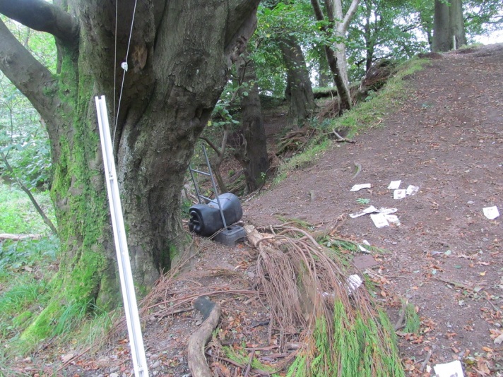
This made me melancholy. A stone circle had been lost – so be it. But it had been lost and not adequately compensated for. A Food Vessel, Urn and a clump of dead rabbit / otter had been added to the archaeological record, dots on a distribution map (except for the rabbit unless there is a distribution map of Bronze Age wigs), but we don’t even know how many megaliths once stood here. Tillicoultry House with its amazing standing stone lined drain was demolished around 1960, another victim of progress, while the current location of the rock-art-marked stone, visited and visible to Ronald Morris in 1966, is unknown. The Food Vessel is held in the collections of the National Museum of Scotland.

There is nothing to let people whose houses are literally metres from where a prehistoric centre of ritual, ceremony and burial once stood know about this, no noticeboards that might inform casual passers-by, a lack of an app or virtual reality ancient version of this place to download. This monument has gone, a victim of all sorts of Victorian hoo-ha. And not only was the monument destroyed, but the place where this monument once stood was destroyed, atomically removed. Once it was removed, the megalith was split up into pieces and then it was later destroyed again, a second death. The burials that were left behind were recovered to an extent, but are now hopelessly dispersed.
There was no deal here – this was a hard extraction, and once the stones had fallen from this cliff edge there was no going back.
I have often said in the past that urban prehistory is not about a sense of loss, or sadness, and this is still the case. But for Cunninghar there have only been bad outcomes, as bad as it gets, and it seems a hopeless case, all that remains being this sad story and footnote in the National Monuments Record of Scotland.
Melancholy is not the same thing as sadness, nor is regret. What I regret about some urban prehistoric sites is that their destruction was in vain, the price paid too high.
Prehistorica melancholia.
Sources and acknowledgements: This post benefited from many conversations with Helen Green about heritage, development and compensatory measures (or lack thereof).
Little has been published on Cunninghar, or the variants of spelling of that name that are out there (Cuninghar, Cunningar). Two articles were published in close succession in the Proceedings of the Society of Antiquaries of Scotland about this site, both referred to above. The first of these was Robertson’s 1895 effort, ‘Notice of the discovery of a stone cist and urns at the Cuninghar, Tillicoultry’, in volume 29; the second Cole’s 1899 ‘Notices of the discovery of a cist and urns at Juniper Green, and of a cist at the Cunninghar, Tillicoultry, and of some undescribed cup- marked stones’ (volume 33). Both can be read online for free via the Society webpage. The image of the Food Vessel came from the Robertson paper, the cist plan and rock-art ‘photo’ from Coles, and the latter also provided the quote near the start of the post.

I’ll mention two things:-
1) The gravel quarry at the top end of Kilmartin Glen – a shame and a disgrace. A relatively recent shame and disgrace, too.
2) I wrote this to someone a few years ago – a bit of a different thing, but…
“You mention Baclodiad y Gawres, also on Anglesey. We visited there, some years ago, and I found it very disturbing. This is more of my ‘feeling’ stuff, not precise, at all. We went to visit the cairn, and, as you’ll know, it’s encased in concrete. As far as I was concerned, it was ‘dead’, or, almost. It’s a terribly un-happy place, and it shouldn’t be, that’s not what it was raised for. It was dreadful, to be there. We went up on top of the mound, and I tried to channel light, back into the place. We met a lass, there, who I thought was practising Reiki, on herself, it turned out she was doing Reflexology, but I told her of how I felt about the place, and she said that was why she went there, to sit and try to produce good feeling. I won’t witter at you about this, Euan, as I don’t think it’s your ‘thing’. I’m mentioning it, as what can happen when folk totally mis-understand what a place should be, and treat it that way. All these places, are to do with light. With life, and death. But, light, lines to follow, to ‘catch’ the light. Light. Barclodiad y Gawres, has been mis-used by the Department of Works, or whoever it is. When we returned to Suffolk, I was telling my friend, Lauren about it. She said she had a friend, on Anglesey, who is a Druid, and she’d ask him to go there, and try to bring some light and life back to the place. It’s so wrong, when such a place, becomes like that. When you mention that there is a carving there, albeit a “crude” one, which may be connected with the ancient folk finding their sight-lines for observatories connected with the passage of light, that makes it even worse. Barclodiad y Gawres stays in my mind, as a sad, dark, gloomy, clammy place, compared to Bryn Celli Ddu, which is………… what it should be.”
On a positive note – it’s Diwali!