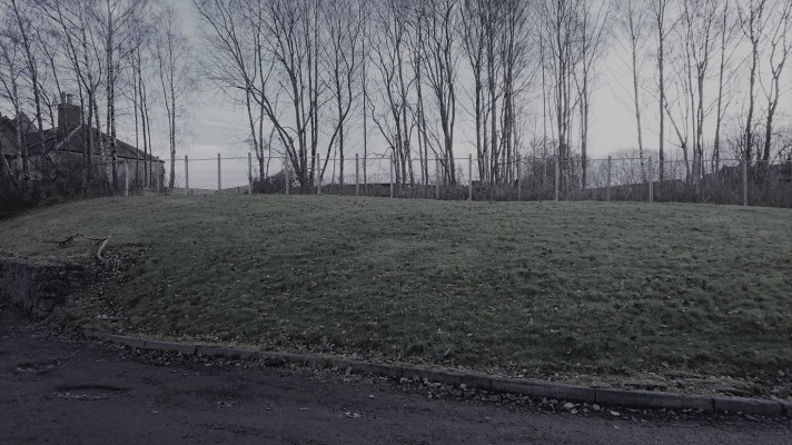
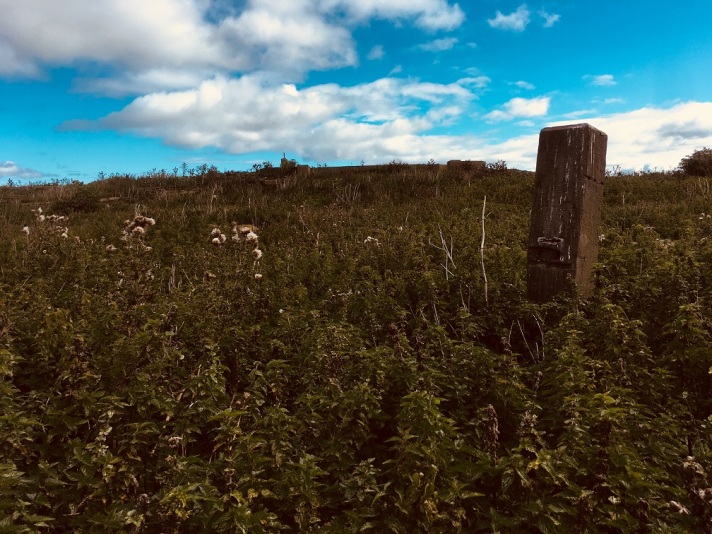
Fact check: the letter that forms the basis of this post and my Lennoxtown visit was published in The Scotsman newspaper. As with many other Ludovic McLellan Mann observations, there is no corroborating evidence for the presence of this Knowe, nor its folk and archaeological significance. If such a mound existed, its contours have not troubled mapmakers. And it is commonplace to find that prefabricated houses from the 1940s were not ‘temporary’, even if this mound was. The ruinous ground behind the three bungalows on a natural rise was once occupied by the Free Church of Lennoxtown, which was used as a drill hall for “D” Company, 7th battalion, Argyll & Sutherland Highlanders during the First World War, and a school also once stood upon this acclivity.
Putative location of The Holy Knowe (OS map, 1956)
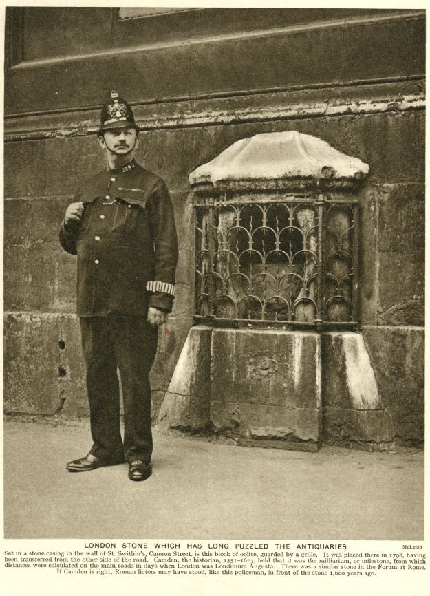
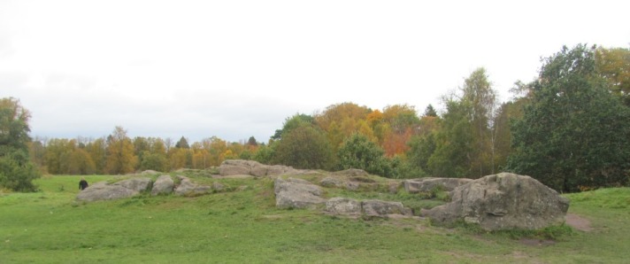
There can’t be much left to write about the London Stone, an urban megalithic curio that The Guardian newspaper called a ‘psychogeographer’s landmark’. This strange roughly cuboid limestone block, located at 111 Cannon Street in London for at least half a millennium, may well be a solid lump of stone but it consists more of myth than molecule.
There are so many legends associated with this roughed-up beige 76 kg stone block that it strikes me as weird that it has consistently been located in such an un-legendary location. Although in the past the the London Stone has by historical accounts been set into the wall of the former St Swithen’s Church, it has also in more recent times been contained by a rather crappy cage in the wall of a WH Smiths and before that a Sportec sports shop and even The Bank of China. This was after a near miss during the Blitz.
Above two images both Rex / Shutterstock, sourced from The Daily Mail 12022016
There is little point in rehearsing the many stories associated with the origins, meaning and biography of the London Stone. There is such a depth of lore about this object that I am sure that it deserves more than the one or two paragraphs afforded in most books about London; certainly, a lack of time permitted me researching this as rigorously as I would have liked.
For the time being, to cut to the urban prehistoric chase, let’s focus on how old the LS actually might be. Peter Ackroyd (London: the biography, 2001), suggests that it, ‘is of great antiquity’, but ‘as a perishable stone, cannot be assumed to survive from prehistoric times’. Two pages tell the story of the Stone in John Matthews and Caroline Wise’s The Secret Lore of London (2016); they describe is a ‘worn stump’ and a ‘geomantic mark-stone’ of, at oldest, Roman origin.
Reproduced in The secret lore of London (Matthews and Wise)
In The Stones of London (2012) Lee Hollis suggests that the London Stone may be little more than a Roman gatepost that has taken on all sorts of myths and legends depending on the political needs of those who told those stories. Ed Glinert (The London Compendium, 2004) calls the Stone a ‘totem for the city’s safety’ which has prehistoric overtones, but more broadly draws on myths about the Stone not being removed from the city. And so on. Each account draws on the same pool of lore, include lots of secondary referencing, and indicate the limitations of the historical text as a source as authors attempt to peer back into the murky mists of time.
There is much that could be done from an archaeological perspective to add to the already-colourful story of the London Stone. There have been various different reliquaries that have held the LS, and this would be an interesting line of investigation both in terms of the form but also materiality of these cages and boxes, as well as telling us something about how people engaged with and interacted with the Stone, and what levels of control were exercised over that engagement.
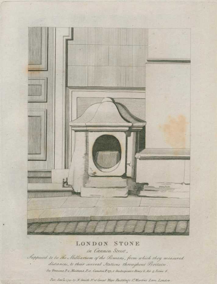
From John Thomas Smith’s Antiquities of London (1791-1800)
Or perhaps a mapping exercise could be undertaken, considering the various different locations that the London Stone has been placed, on both sides of the street and with slight variation, and other possible places of repose. The location of the Stone vertically might also be traced, with pavement level and higher in the church wall just two variations. Again, how people encountered the London Stone and spatially where it was located might shed light on its social role, and this includes the bodily inclination needed to view the monolith: looking down or peering up.
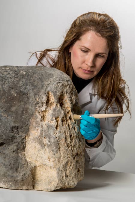
Helen Butler does some conservation work (c) Museum of London
The stone itself could (and I’m being fanciful here but what the heck) be the object of scientific study, with techniques such as XRF and Ramon Spectroscopy able to discover paint, blood, sweat, tears and semen stains (OK, maybe not the latter, that would need a CSI-style UV light source…). Use-wear analysis would be able to (theoretically) shed light on the exact metallurgical properties of the sword that was used to strike the London Stone by rebel leader Jack Cade in 1450 (but not what he had for breakfast that day).
Stock image of Jack Cade waving his sword about, various sources online.
It is interesting how many old drawings of the stone focus on the detail of the container and not the stone, which more often than not seems to be a shapeless lump. This is perhaps because geometrically this thing is a shapeless lump. The Mail Online described it as looking like, ‘a large piece of leftover masonry’. So a 3D model of the stone would be nice so capture its slightly strange shape and rough surface, and might shed light in the mechanism of the breakage of the stone (it may once have been larger), as well as highlight historic damage and carvings.
(c) Europac 3D
Indeed, after I had written these words, I found out that such a scan has indeed been undertaken by Europac 3D. This laser scan, undertaken to sub 1mm resolution, was done using Arctic Space Spider which sounds like something from a John Carpenter film but probably isn’t. Interestingly, this ‘revealed several man-made carvings, one of which is believed to have been made when Jack Cade entered London’ although I think that one was already visible with the naked eye. I think full results are yet to be published, but at last the Stone can be viewed as something other than a blurry block in a photo or as an etching of a blob in a box (see below).
Reproduced in Ackroyd’s London: the biography
The London Stone, as it happens, recently spent a couple of years in the capable hands of the Museum of London’s archaeologists, and they undertook some conservation work on the Stone as well as putting the thing on display with a lovely purple background in their museum (and getting the aforementioned scan done).
(c) Museum of London
One of the key areas of their presentation of the stone to the public was some myth-busting, and blimey there are lots of myths and stories attached to this object that they wanted to bust.
Myth number 1 that they ‘bust’ was: It has stood in London since prehistoric times and Myth number 2: It was an ancient altar used for Druidic sacrifices. Both of these centre on the suggestion that the LS is the remnant of a much larger prehistoric stone or even a broken standing stone. However, MOLA question the urban prehistory credentials of this rock, and thus by extension the legitimacy of this blog post. In fact neither myth is really busted, but rather some of the historical biography of the London Stone cited, with the underlying suggestion that there is simply no evidence that this was ever part of a prehistoric monument. They push is back possibly to Saxon or Viking times, maybe even Roman, but no earlier.
Assumed by some authors such as John Strype and William Blake to be a pagan stone, in fact this had no basis in fact and simply confirmed their own romantic proto-druid mythologizing, captured in this stansa from Blake’s Jerusalem:
Where Albion slept beneath the Fatal Tree, And the Druids’ golden Knife Rioted in human gore, In Offerings of Human Life… They groan’d aloud on London Stone, They groan’d aloud on Tyburn’s Brook…
Finally, MOLA get to the point and conclude: “There is no evidence for this, and London Stone, whatever its purpose, was certainly not erected before the Roman period.” Boo.
That’s fine, and also true. There is no evidence that the London Stone is prehistoric in origin. But does this matter? Some in the past have believed it to be the case, and some still do. The prehistoric credentials of this stone are nothing to do with reality, but perception, and this is often the way with odd megaliths and other urban prehistoric miscellany. We might as well ask: how old is a piece of stone? Because the fact that the London Stone is an oolitic limestone means that it is very old, dating to before 1,000,000 BC. It depends on how one frames the question.
Source: London TimeOut 05102018
Visiting the London Stone today seems to me a legitimate exercise in prehistoric speculation now that it has been re-instated in a new shrine on the former WH Smith site, still 111 Cannon Street.
The Stone has only been back in its old location for a few months, although now the weird cage has been replaced with a glossy shiny glass-fronted display box. This reliquary appears to be a throwback retro design referencing older versions of the container for the Stone, some of which are pictured earlier in this post.
Two black plaques sit on either side, one of which explains that we know bugger all about the London Stone, while the other says the same thing in braille (I assume).
The right-hand information panel begins with a malformed tripartite sentence.
Above the ceremonial repository, there is a simple bookplate inscription saying LONDON STONE and this appears to be part of a limestone facade of the fancy new building, thus mimicking the materiality of old Stoney itself. Has the architectural design for this glassy building been designed with the LS in mind?
This has replaced the crappy but endearing WH Smith context of yore, and the new mini-high rise building is rather more glassy and glamorous. The London Stone has clearly gone upmarket. This is certainly a gentrification from its earlier status, described by Ackroyd as, ‘blackened and disregarded, by the side of a busy thoroughfare‘. Nonetheless, the latter part of this statement remains true.
The glassy nature of the building within which the LS is now encased affords views behind the Stone, a glimpse that was not within the gift of the stationer WH Smith. Here, disappointingly, the oolitic lump appears to be concealed behind a wall of mdf, although there is the hint of a small panel that might be removable with a smuggled screwdriver once this establishment opens for business, whatever that business might be.
Observing those walking past the London Stone suggests that this is, at worst, of no interest, or at best, an over-familiar landmark, as few pedestrians paused to pay their respects. The noticeboard detained a few men with suits for a minute or two, while a woman with a pram did look at it as she perambulated past.
I got the sense that this is a lonely Stone as I lurked in the area for far too long. This is perhaps why this geological curio literally engaged me in a short twitter conversation, expressing the surprising and hitherto un-expressed desire to be called Kevin. I duly obliged, walking past and affording LS this new moniker with a jolly shout of ‘hello Kevin’, although as yet this new persona has not been adopted widely.
Shall we ever get to the truth of it? No, of course not. And why should that matter? When we ask ‘how long is a piece of string’ we don’t expect a factual, empirical answer. The London Stone’s prehistoric credentials are not in doubt as far as I am concerned, elements of a story long told, whether that be the one about it being a broken standing stone or having served as a druid altar or some other sacred megalith of yore.
It doesn’t matter how old the London Stone is: we only need believe it to be so. This is rich narrative, a stone that does not roll but has gathered spiritual moss. As AD Cochrane has noted, ‘Down the centuries a parade of charlatans, poets, modern psychogeographic writers, alchemists, historians and eccentric clergymen have enriched the mythology of London Stone‘. If this isn’t prehistory, I don’t know what is.
There is one source that I was able to find that suggested that this misshapen hunk of rock was once part of a prehistoric monument. In a review of the former London Stone Pub (107 Cannon Street) a contributor to the website ‘Fancy a Pint.com‘ suggests that the Stone was, ‘possibly part of an ancient stone circle’. The same review also suggests that the pub contained, ‘gargoyles, cocktails in test tubes and other assorted horror ephemera’ so perhaps it is for the best that it closed a couple of years ago, to be replaced by The Cannick Taps.
Photo: Fancyapint.com
Rare views inside the London Stone pub, which appears to have been a gothic extravaganza of poor taste, suggest decor that mimicked the grey metal cage that enclosed the Stone until fairly recently. Bad art imitates poor cage.
Trip Advisor – interior of the London Stone pub (deceased)
How old is this piece of stone? Who cares.
The London Stone is as the London Stone does. LS if you are into the whole brevity thing.
The London Stone abides.
Sources and acknowledgements: if you want to find out more about the London Stone, ask it questions on twitter via @thelondonstone – it / Kevin might answer back.
It is a cliche to say that archaeological sites are fecund with the ghosts of those who occupied, lived, worked, cried and laughed in those places in the past. Even the most unremarkable ancient place is likely to have been passed through by countless living but now dead humans and animals. Mute witnesses whom we cannot call to account. Spectral presences that haunt our efforts to write their stories with all of the constraints of the archaeological record and our imaginations.
These phantoms of the past are always present as we visit archaeological sites (as we clinically call them), just invisible from the corners of our eyes. The dead are knocking once, twice, if only we would listen. Warping the thin rood screen between now and then, past and present, and bending the wind to their will. Light cannot pass through them, and forever their ancient haunts will be opaque to us, clumsily accounted for in our narratives, our excavation reports, our notes. Archaeologists are amateur ghost story writers with neither the elegance nor the critical ambiguity of MR James.
Urban prehistory sites suffer more than most, and at this time of the year in particular. The harsh entombment of concrete and tarmac, brick and gabbion, combine to dull the kinetic urgency of the dead users and makers of prehistoric places with the misfortune – the curse – to haunt places now occupied by a different strain of zombie: commuters, shoppers, drivers.
Only school children and certain sensitive individuals remain attuned to the specific frequency that prehistoric ghosts broadcast via. Sometimes the past bleeds through though, as if in a seance, and becomes a matter of record. Twisted clues offer fragmentary accounts, uneasy truths, partiality. We place our trowel on the ouija board trench surface and hope that a spirit will animate it, write the story for us, shatter glass.
Archaeologists act in advance of urban expansion and development as ghost-busters, using highly sensitive equipment to pick up the wavelengths of the spirits of prehistory, then extracting those spirits by way of storage bags and boxes that are transported far away from the site and blessed with the obscure rituals of the trinity of lab analyst, the archivist and the curator. We do everything but consult with priests, and can be found in libraries furtively flicking through a dusty grimoire.
As archaeologists we often state our case ‘in all seriousness’ and yet this is simply to cover up our fears, and insecurities. We laugh off the uncertainty of the past, the questionable proofs of prehistory, supported by the safety net of out ontologies which when analysed have all the supportive qualities of the spiral staircase in the library in Shirley Jackson’s The Haunting of Hill House.
Like many a Poe-inspired mansion in a Roger Corman movie, everything may end up in a suspicious but cathartic conflagration. All of us wish to be Quatermass, to discover our own Pit, and with it our fate and destiny.
We must embrace the ghosts of our ancient past, strain to listen to what they have to tell us, get everything on tape, play it back over and over again to hear their story until it stretches and snaps. For we ignore them at our peril.
an accumulation of scree at the base of a cliff or steep slope
an ankle bone
a fortification
Automatic writing
The pressure of my thumb caused just enough 0.7mm graphite to ooze from my pencil. Sitting on a train, breathless, fumbling in my bag for the book. Applied Ballardianism by Simon Sellars. This crumpled paperback that had become the roadmap for my increasingly eccentric visits to places in heavily urbanised or industrialised places with obscure prehistoric predecessors. This was no longer enough, I came to realise after writing 116 posts for my blog. I needed new kicks, fresh experiences, the hard stuff.
I opened Sellars’ book up at random pages and saw continual relevance to my own condition, just as the unreliable narrator of this fever-dream of a novel had also done. I began to scribble in the margins, automatic writing. The sections of the book that I applied marginalia to appeared to be random but were perhaps not. Bunker Logic. Scar Tissue. Emergence.
This book was the archaeological fieldwork guide that I had always wanted. More profound than Barker’s Techniques of Archaeological Investigation. More informative than Drewett’s Field Archaeology. More grounded in reality that Hodder’s The Archaeological Process. More emotionally charged than the MoLAS archaeological site manual (3rd edition).
I came to realise that as a rulebook for surveying the deep time in our world one need do no more than read the complete fictional works of JG Ballard, Applied Ballardianism and Paul Virilio’s Bunker Archeology.
Through this psychogeographik grimoire, I had found my hard stuff. The hard stuff of life.
The midden.
Calcium Cairns
Middens are indicative of accumulation and disposal, rise and decline. They are the ultimate material expression of consumption.
Middens mark the rise, fall, and will indicate the return of, prehistory.
Middens are contingent on abandonment, emergent in every place that humans exist, from a deserted military island to the urban core.
Middens passively grow, while awaiting collapse.
Middens are our cultural scar tissue, which we cannot help but touch.
Cairns of calcium and carbon.
In the Mesolithic of Oronsay, hunters and fishers would bury human finger bones in their shell middens.
In the Neolithic of Orkney, farmers would use midden material to insulate their houses.
But middens are not just of the past. Everywhere around us are middens-in-waiting, potential-middens, partial-middens, middens-in-hiding, proto-middens.
Living is an act of middening.
A Gruesome Inventory
The kitchen-midden was discovered on the far side of the small estuarine island of Inchkeith in 1870 at the base of a slope. This artificial organic talus consisted of cooking-debitage, eating-scree, of unknown date and origin. The midden was monumental in its scale, up to 3m high, thick with greasy charcoal.
Baskets of bones were removed from this midden for analysis back in Edinburgh. The scientist tasked with the analysis of these bits and pieces produced a gruesome inventory, scraped from the pages of an anatomical manual, notes from an animal autopsy.
Basi-occipital and basi-sphenoid fragments of grey seal skulls. Mastoid process and temporal fossa of sheep. Head of the ulna of a sheep. Fourth cervical vertebrae of a pig. Head of left tibia of an ox. Cannon bone of hind foot of bos. Toe bone of bos. Parts of jaw, and several teeth, of horse. Jaw bones of the rabbit. An assemblage of alien species.
Many shells were found too, listed in the analysis like an incantation. Tapes pullastra. Purpura lapillus. Pecten varius. Ostrea Edulis. Pecten maximus.
It was concluded after this analysis and repeat visits to the island that, ‘there is no evidence as to the period when these rejecta were first cast forth’.
Cast Forth in the Forth.
Urban Midden
Hunter Street. There is no such thing as a coincidence so I told myself as I cut up from the Barrowlands Ballroom and headed towards the urban prehistory. I turned onto Hunter Street, folding a map and stuffing it into my back pocket. Across a railway line, over an abandoned tunnel. Ahead of me now were the rusty skeletal remains of warehouses, the Victorian city excarnated, exposed as if on a osteoarchaeologist’s slab.
The sign of the Hunter was affixed to a street light that had beside it a rusty totem pole, its evil twin, pock-marked with corrupted spirals and corroded cupmarks.
Two drunks in navy shell suits kept appearing during my walk, as if they were being projected for my benefit on a loop by some unknown projectionist. One of them spoke to me tenderly, momentarily breaking the fourth wall, confusing me for his partner in grime, before realising his mistake and flickering out.
I was looking for hunters in the city, middenscapes in the shadow of the industrialised Tennants’ Brewery, makers of liquid gassy capitalism. From my perspective as I entered Barrack Street it seemed that the aluminium pipes that emerged from the brewery were connected directly to the Necropolis, Glasgow’s city centre cemetery, and for a moment I speculated that this must have been for the exchange of fluids. Through the beer haze I could also see the outline of Glasgow Cathedral, one of Ludovic Mann’s ancient Glaswegian pagan places, his Temple of the Moon. There is no such thing as a coincidence.
Back on Hunter Street (confusingly re-appearing) I reached my destination. A block of modern flats and some old brick-built industrial units on Duke Street where a shell midden had been found during construction works in 1985. Ancient oyster shells had been found on the spoil from the job, and identified too late as being of archaeological significance. In prehistory, I reminded myself, everyone was swallowing oysters all of the time, as they were, as in Victorian times, not simply the preserve of the rich. The shells were then dumped in a pile, calcium cairns, middens.
The industrial unit was orange and glowed in the late afternoon sun, raking across the facade and revealing ghosts – ghost signs, phantom lettering, a typeset palimpsest of failed and out-dated businesses. The building was dominated by a monstrous sign: JAS. D GALLOWAY. TYRE DISTRIBUTORS.
I wondered around the block onto a different section of Barrack Street (I was becoming spatially disorientated). I passed a pub – the Ladywell, suggesting an ancient spring or holy well once stood here. On the wall of a neighbouring car repair shop, an occult symbol had been crayoned onto a white-washed wall. Was it a spiral, or a malformed cup-and-ring mark, or a reversed number nine – or a shell, a mollusc, a midden-component?
A constellation of coincidences? I reflected on the words written by Marion Shoard and quoted by the fictional headcase Philip in Applied Ballardianism. Urban edgelands allowed us to see ‘history as in the stratified layers of an archaeological site’. In essence, socially fundamental constructions, materials and infrastructure often become restricted to urban edges. Can’t live with them, can’t live without them.
In prehistory, those conflicted spatially dangerous fundamentals were middens.
Organic Rejecta
under the flats and the factories are places of accumulations of shells and bones and twigs and nuts and seeds and pips and marrow layers of practice the stratigraphy of a lifetime of generations of meals of daily routine of repetition and habit and routine and the accumulation of shells and bones and twigs and nuts and seeds and pips and marrow under the people under the streets pressing against the walls of the basements pressure toe bone of bos parts of jaw and several teeth of horse jaw bones of the rabbit tapes pullastra purpura lapillus countless rejecta under the flats and the factories are places of accumulations of shells and bones and twigs and nuts and seeds and pips and marrow calcium carbon cairns
The Island of Dead Birds
Inchkeith today is a very different place from the island where the kitchen midden was recorded in 1870. Militarisation began in 1879 and continued throughout the first half of the twentieth century transforming this small rocky eminence through the construction of concrete bunkers, control buildings and the infrastructure of ammunition supply.
This was a defensive, reactive place, but never saw action.
After this brief flourishing, the island has more or less been abandoned to nature (with most of the personnel withdrawn in 1943) like some kind of social experiment.
Quite by chance, this island of precaution has become an emergent prehistoric landscape with its own monuments, its own concrete vocabulary, its new middens.
The porcelain cairn –
The fallen megalith –
The shit-stained monolith –
The island has its own sacred geometry, ghost paths and leys –
Bunkers abound, underground spaces for the containment of ammunition and men. The walls are burdened with a sinister anatomy of coat hooks and shelf supports.
Animals have become complicit in re-making prehistory, the island covered in bird-build middens, accumulations of shells and bones and twigs and nuts and seeds.
Now, in its abandoned state, this concrete island is becoming something … other.
Talus
Middens
Mummified mice
Nests within nests by nests
Scattered cartilages and cartridges
Shells upon shells under shelves and on skulls
Pips amidst pipes and petrification
Calcium cairns. Concrete cairns.
Broken bunkers and bones
Talus Talus Talus
Middens.
Concrete Island
“Abandoned on the sand of the littoral like the skin of a species that has disappeared, the bunker is the last theatrical gesture in the endgame of Occidental military history…. (Virilio 2014, 46).
Dirty Edgelands
What is urbanisation but an accumulation?
A midden with prehistory as its dirty edgelands, if not in space then certainly in time.
We are all middening, us town and city dwellers.
Living on our own islands with our own futile defences, bunker mentalities, surrounded by lots of shelves.
Cultivating our prehistoric sites, curating our legacy, hoarding our single-use plastic debitage, accumulating our very own midden.
And when our megaliths have collapsed, our material culture turned to dust, our bodies broken down, all that will be left of us are our middens and our single-use plastic.
Our middens will become the focus of ritual extraction and deposition by birds.
We are tomorrow’s urban prehistory.
Sources and acknowledgements: I would firstly like to thank Gordon Barclay for inviting me to spend a day visiting various fortified islands in the Firth of Forth, amongst them Inchkeith. The few facts about that island that appear in the narrative above come from Gordon’s excellent handouts to accompany the trip and he appears in one photo striding towards an anti-aircraft gun position.
The account of the kitchen-midden found on Inchkeith in the 1870s is (you can find it online by googling the title of the paper): David Grieve 1872 On the discovery of a kitchen midden on Inchkeith, Proceedings of the Society of Antiquaries of Scotland volume 9, 452-55. The jumbled list of animal bones in my post is adapted from this paper.
The limited information available for the Barrack Street / Hunter Street shell midden can be found in the canmore entry for the site here, and Sloan recorded in the 1985 edition of Discovery and Excavation in Scotland (pg 46):
“Deposits of oyster shell were reported from approximately this location during housing development in 1982. Although reported too late for active investigation a sample of shell was recovered from builder’s spoil; remains in the possession of the Committee for Early Coastal archaeology”.
This could be a Mesolithic site, but it could also be medieval, or anything in between. We choose our own myths about the past.
Ludovic Mann’s moon temple writings are included in his 1938 short book Ancient Glasgow: Temple of the Moon.
I must finish by paying a debt of gratitude to Simon Sellars for his brilliant novel Applied Ballardianism (Urbanomic, 2018) for inspiring aspects of this post, and leading me to the chapter Edgelands by Marion Shoard (quote from this in the blog post) in Jenkins’ book Remaking the landscape (Profile Books, 2002). Sellars also led me to the majestic Bunker Archeology by Paul Virlio (my version being published in 2014 by Princeton Architectural Press). The image from that book was sourced from the Amazon page for this volume and a credited quotation appears above as well.
The definitions that start this post were adapted from wikipedia.
Urban green spaces are great locations for urban prehistory to hide itself away, existing in the cracks in the city that still exist, offering entry points to wormholes that go way back in time. And yet for some reason these precious prehistoric portals are often unheralded, and frequently ignored. And not just by visitors to the park. But also by park authorities, those who market and map parks, make signs, host park websites, produce publicity material and whose task it is to engage the public in park life.
Urban prehistoric sites may sometimes be partial, and often difficult, but they are seldom unrewarding.
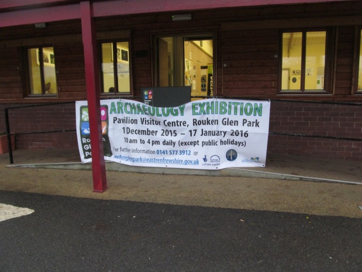
In this post I would like to recount a recent visit to see one such site, a rock-art panel in Rouken Glen park, East Renfrewshire. I naively imagined before my walk that this amazing resource would be something that was viewed as a visitor attraction and point of interest within the park. I foolishly believed that when I parked my car and walked into the part itself signs would point me the way, thus supplementing the rather poor maps I had been able to source online. Yet what happened surprised me, and what appeared initially to be a simple task turned into a more of an educated guesswork wander which took me off the beaten path until I found a beaten path with the rock-art hidden and almost forgotten, 5m from a railway line.
Thankfully, as the entirely fictional news clipping above suggests, the gaze of archaeologists and park managers – and hopefully visitors to the park – may well be turning towards this rather sad and lonely piece of railway rock-art. The light of lasers has been shone on the rock and it has to be hoped that it will illuminate it so that it becomes as bright as it once was, several thousand years ago. But in the meantime, I have this suggestion:
Then a walk to find cup-marks on the 25th October 2015
My walk, overlain on the official park map
I arrived at the car park on a damp Sunday morning and proceeded to walk straight to the small pavilion which I knew hosted an exhibition about the park itself. Beside this building an extensive and well-used playground throbbed with sound and nice screams, and children climbed on megalithic blocks and ran around within timber roundels.
The roundel in the playground
Inside the pavilion was a light and airy exhibition with a focus on the heritage and geology of the park. I found little here on the rock-art however. One panel was entitled Mystic marks on the stone. Beneath a grey picture with some shadowy holes was a bit of text that said: ‘There are two rocks in the park with Neolithic … or later Bronze Age carvings”. Two?? That was a surprise. The label then concluded unhelpfully, ‘No one is sure what they mean’. Great. At least try!
There was no indication of where either of these rock-art panels might be, and they were not marked on any of the fistful of maps and leaflets I picked up as I left. I was on my own.
There were also no signs outside saying helpful things like ‘Rock-art this way’. And so I randomly headed along one of the paths that cut southwards across the wide open green expanse of park.
Then, almost immediately, and right in front of me, was a standing stone, on a low grassy mound just to the west of the path I was on. It was clear this was a stone with an affectation, namely an asymmetrical profile with a needle sharp protrusion on top. In front of this monument was a little board that told me that this stone was erected in 2006 to mark the centenary of the park. A tiny council logo sat beneath these rather grey words. The slate grey monolith emerged from a scuffed grassless patch and an green-orange-leaved tree overhung it. Sun rays painfully wriggled through the leaves to illuminate the backside of the stone.
I negotiated a few paths of various widths and surfaces, as well as dog walkers and joggers who were being timed by a trainer in a tracksuit and decided to head down towards the river with an aim of crossing a bridge further south which would take me to the rough ground where I knew the rock-art must be located. I walked along this silent path, with sandstone outcrops jutting out below me. Alone with my thoughts.
And my chalk.
After a while, the wooden barriers and fence posts began to take on rock-art motifs, transforming in front of my credulous eyeballs.
I realised there would be no signs. So I followed the official park map with my own annotations. Emerging at a crossroads I crossed a bridge. From one of the bridge barriers was a wet toy donkey hung on a rainbow noose, a symbol from a crazed alternative tarot card. Lost, like me.
The hanged donkey
Beyond the bridge was a huge rock outcrop. I scanned the surface. I crawled all over it. There was no ancient rock-art here. But there were fag packets, broken glass, cigarette butts. And the faintest traces of weathered writing, indistinct letters and words, in pen and chalk. A rock that was not marked in prehistory. But marked now, breaking an ancient taboo.
Beside the rock I found two train tickets, separated from one another by several metres. Both tickets bought by or for a child, from different places, to different destinations. Both outbound, but neither to here.
This is a transitory place, near a railway line but curiously not a station. One-way only, a place for the young, for concessions with restrictions of carriage.
And from my hog-backed rock viewing position I could see a circular enclosure, defined by small trees and differential lawn mowing regimes, a space fine trimmed. In its centre was a megalithic capstone, and beside that, a red lipstick contained within a purple bullet-like capsule, make-up for the dead.
I sensed I was getting closer. The planets were aligning. But to get to my goal I had to leave the path and so I did this at a suitable location and plunged into the trees and the mud and the long grass and the weeds. Soon I was thoroughly lost and apparently no closer to my destination.
I climbed up a slope and emerged, blinking, onto a golf course, with golfers lurking nearby holding their golf sticks and golf balls and golf bags. Back down into the woods I hid from them, afraid that a twig snapped underfoot would bring down their wrath upon me. Then I though ‘sod it’ and climbed back to the fringe of the golf course and used it as a shortcut to get to the edge of the railway line.
Then the vegetation got really thick. I forced my way through branches and weeds, with roots clinging onto my ankles and brambles tripping me up.
Like Frankenstein’s monster, I lurched through the chest-high plants, my arms raised in surrendered, a face full of confusion for a world I no longer understood due to a recent re-arrangement of my limbs.
Then suddenly I found a nice clear path that ran beside the railway line and I realised there was probably an easier way to get here than the route I had just taken. But I had come through a rite of passage (I consoled myself), I had got here the hard way (so I told myself), I had gone off the map but had found the rock-art.
A single, solitary cup-mark. Lonely. Quietness punctuated by trains speeding by a few metres from where I stood.
The cup-mark has a wonderful organic quality and alone in the woods I found it difficult to determine the soft edges of the pecked hollow motif on the pliable and plastic rock. The cup circle held some water and a curled brown leaf when I had arrived but as I stayed and stared, it took on a new character, organic and vital, life-giving and potent, fecund.
And so after staying here for quite some time, under the influence of the vibrating tracks behind me, I set off, along the path.
Ambiguity abounded. Trees, spirals, cuts, knots, twigs, tree rings, rock-art rings, stone and wood, blurred together in this place and on this path.
There was a tree that beneath the bark was blood red. I shivered as I passed it but made my mark.
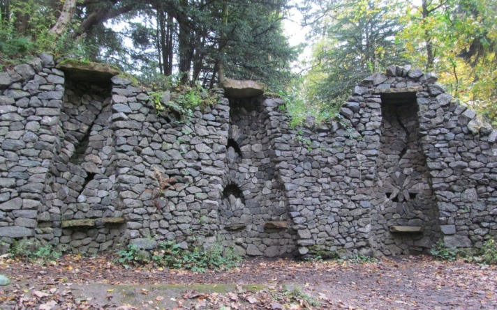
Back out of the woods, the confusion seemed to pass, and soon I was just another person out for a Sunday stroll, with my path back to the car more certain as I got my bearings. En route I passed more stone monuments, this time in the form of lime kilns, some of which had candles and shrines in alcoves. These monuments to industry had been split open, half-sectioned, to expose the megalithic workings within, creative voids, spaces for air and material transformation, now places of candles, coins and flowers.
Then – my walk was over. The rock-art had been found. My boots were muddy and my hair was ruffled.
But it was done.
Followed by A More Formal Record of my own making
Notes on an exhibition
During 2015 Archaeology Scotland carried out a series of events in the Park to engage local people and park visitors to its archaeological heritage. These included walking tours, talks, survey and mapping workshops, laser scanning, a Heritage Festival and small-scale excavations. This was part of the DigIt! year of events and appears to have been a success. The project had a high visibility within the park with notices and posters up all over the place advertising the programme of events.
In early December a small exhibition based on the work done was launched with a lecture by Phil Richardson. I visited the exhibition about a week after it launched.
This is a really good example of how archaeological methods and techniques can be used to involve and energise the public (although in the photos I saw a lot of well-known amateur archaeologists and some of my students). Crucially, for me, this is not about saying something new about the past – although this can be an outcome – but rather it helps people today, to come together, work on something, see tangible outcomes and have a positive experience. It is also about the improvement of the green space for all users, whether this is displays like the exhibition, or better information about the park itself, and augmented visitor experiences.
Sadly, so far, this has not resulted in the new cup-and-ring-lings being any more visible in the park, and perhaps this exhibition, and the results of the work that underpinned it, will be as ephemeral and short-lived as my chalk markings. I hope not. I hope the cup-marks can become signposted and foregrounded in some way so dog walkers no longer rush past, children don’t need to create their own – and flâneurs will never again struggle to find them.
The rock-art, to benefit Glaswegians and other visitors today, can’t stay hidden anymore, off the map.
Fragments of a site, documented poorly, beyond living memory. The excavation of a Bronze Age cist cemetery in a sand pit on the south-west fringe of Glasgow in 1928. By Ludovic Mann, who else? Piecing together the pieces, re-telling the story, making sense of it all. All we are left with: fragments, pots, photos, rumour, myth, mystery. Only fragments of a site, material clues, things, both familiar and unfamiliar. Found in a sand pit on a ridge beside Mount Vernon: a place now a quarry and landfill site. Fragments. That’s all we have. As archaeologists, as (pre)historians of Glasgow, the voice of the past drowned out by the quarry machine, the truck, the motorway. The quarry and the cemetery. The cemetery and the quarry. The cemetery in the quarry. The quarry on the cemetery.
Green-oak-hill
Brown-sand-ridge
Mount Vernon.
Windy Edge.
Fragments of a site, documented poorly, all we are left with.
discovered a complete Bronze Age skeleton in splendid condition
when carrying out excavations recently
on a sandy hillock at Mount Vernon near Glasgow
the skeleton is about 4000 years old
and it is quite possible
that a number of others may be found in the vicinity
as it was the practice of the people of that age
to have tribal burying grounds
over which they raised cairns.
The discovery was made
at a [sand pit] worked
by the Greenoakhill Sand Company.
Until recently
a mansion-house which was built 130 years ago stood near the spot
and it is thought [that] the cairn raised
over the tomb
was demolished when the ground was being cleared to [make] a garden for the mansion.
When some workmen were removing sand
from the hillock
an earthenware vessel of beautiful design
rolled out of a cavity constructed of slabs of stone
the find was at once reported to Mann
who went out and started systematic excavations.
Found three feet below the level of the grass a walled chamber 3 feet 3 inches by 2 feet the sides of which were built of vertical red sandstone slabs as a rule these tombs have a solid stone cover but in this case the covering consisted of about [X] rounded stones carefully packed over the skeleton.
Above these stones
was a handful of bones
which it is thought had been food intended for the dead
but this matter will have to be more carefully investigated.
When the black earth and boulders were removed
there was discovered a skeleton
carefully placed in position facing south-east
exactly along the medial line of the structure
the head was that of the brachycephalic or round-headed type
usually associated with the Bronze Age.
According to the fashion of the time
bodies were some[times] cremated
and the reason why
some bodies were disposed of in this way
while others were simply buried in the usual manner
puzzles archaeologists.
Beside the skeleton was a vessel of earthenware,
in which it was the practice to place food to sustain the spirit
on its journey to
the other world.
Food Vessel from Greenoakhill, held in Glasgow Museums collection, who hold the copyright for this imageLudovic Mann and assorted suited visitors – dead and alive – antiquarians and magistrates – at Greenoakhill (c) Glasgow Museums
Attempt at an Inventory of the Material, Sediment and Human Deposits Excavated by Ludovic Mann at Greenoakhill in the Course of the Year Nineteen Hundred and Twenty-Eight
Six Food Vessels, two pottery bowls.
Five cists, one wooden coffin
One crouched inhumation of an elderly man, one crouched inhumation of a young woman, one crouched inhumation of an adolescent, one fragmentary inhumation, two skeletons, one cremation deposit.
One flint arrowhead, two flint knives, one white pebble, one hair moss garment.
A place of restricted access. A gated community. Movement within mediated by fences, signs, barriers. Specialised and highly regulated clothing needs to be worn to secure entry to the scene. For your own safety. And the safety of others.
A Bronze Age cemetery? Or a modern industrial quarry?
Both.
The cemetery and the quarry, both places of danger, of transformation, places we need protection from, locations and activities that need to be contained.
The wearing of special safety gear is compulsory. Without exception. PPE. Personal Protective Equipment.
Personal Protective Equipment. Sealed off from danger. Wrapped up for safety. Clearly marked out from the others. Distinctive. Safe. Because these are taboo places. The quarry and the cemetery. The cemetery and the quarry. Places where digging into the ground is an act of devotion, an act of conviction, a dangerous and troubling activity, hidden away from the others.
Things happen here that have to be taken seriously and carried out appropriately, according to the rules and regulations.
And access has to be mediated by key individuals – gatekeeper, shaman, foreman, security guards, man in a wee wooden shed.
To enter the inner sanctum.
KEEP OUT. TRESPASSERS ON SITE WILL BE PROSECUTED.
DANGER. QUARRY WORKINGS.
NO ENTRY. DANGER!! PLACE OF DEATH.
Because the quarry and the cemetery are both polluted places. They have depth, they have power, and they are repositories of value and potential energy, derived from underground. Social capital. They are connected places, entangled across and beyond the societies from within which they emerged: Pastoralism / Capitalism. Entangled in networks of meaning that expand beyond this geographical location and its enforced boundaries, beyond the knowledge of any one individual visiting a grave, laying the dead to rest, driving a truck, reading the Daily Record in a cab. Exploded places, shrunk down to just this one place, a dot on a map, a high point, a special place, a pit. The quarry and the cemetery.
During the daylight hours: the traffic in and out of this place is incessant, unrelenting, tireless. It never stops. Back and forth, in and out, a hive of activity, of noise and light. It never seems to end.
By night, it is silent and dead. It reeks of death, of waste, of subterranean detritus. Landfill. Burying the very things and bodies of a community. Murmurations of crows and ravens and blackbirds fly overhead. There is a miasma. A stench. The long dead and their ancient bones. The assorted containers buried and put beyond use: Food Vessels and food vessels, Beakers and beakers, skulls and rusted beer cans. Encased in a shroud of stone and earth and grass. Put in a stone box. Fenced off.
A place of restricted access. A gated community. Movement within mediated by fences, signs, barriers. Specialised and highly regulated clothing needs to be worn to secure entry to the scene. For your own safety. And the safety of others.
A Bronze Age cemetery? Or a modern industrial quarry?
The quarry and the cemetery. The cemetery and the quarry. The quarry on the cemetery. The cemetery in the quarry. The quarry on the cemetery.
Neither one nor the other. Both.
The location of the cemetery today
Sources and acknowledgements: each element of the tripartite structure of this post depended on different sources and inspiration. Image credits are in captions; those with Glasgow Museums copyright came from The Glasgow Story website.
Complete Skeleton. Find Near Glasgow. A poem. The entire ‘poem’ is a very slightly adapted version of a newspaper story about the excavations that appeared in the Glasgow Herald on 27th July 1928.
Attempt at an Inventory of the Material, Sediment and Human Deposits Excavated by Ludovic Mann at Greenoakhill in the Course of the Year Nineteen Hundred and Twenty-Eight. The data contained in this inventory was derived from a summary of the discoveries that can be found in the CANMORE entry for this site. The site has NMRS number NS66SE 2. The title for this short section owes much to the Georges Perec piece ‘Attempt at an Inventory of the Liquid and Solid Foodstuffs Ingurgitated by Me in the Course of the Year Nineteen Hundred and Seventy-Four’. This first appeared (in the original French of course) in Action Poétique in 1976 and was translated and appeared in the Penguin collection of Perec writings Species of Spaces and Other Pieces (1997).
A Perambulation to Wyndy Hege. All images and words my own. The name of this section was taken from the supposed original name of Mount Vernon – Windy Edge or Wyndy Hege. According to Wikipedia.
Field notes
Ludovic Mann’s excavations at Greenoakhill have never been published.
This is a slightly updated version of the text of a paper I gave at a conference held in the Pearce Institute, Govan, on Saturday 17th October 2015. The event was ‘EcoCultures: Glasgow’s Festival of Environmental Research, Policy and Practice’ and it was organised by Glasgow University PhD students Kirsty Strang and Alexandra Campbell. For more information on this excellent event, see the festival Facebook site and twitter feed (@EcoCultures, #EcoCultures). I believe podcasts of lectures and round tables will be made available soon; I will update the blog to include a link when this happens. I would like to thank the organisers for inviting me to contribute.
My paper. Literally.
Walking Ludovic Mann
Ludovic McLellan Mann wrote the secret history of Glasgow.
He sketched out the shape of an invisible city.
He sensed the possibility of another Glasgow, beneath Glasgow.
Beneath their feet. Beneath their trams. Beneath their omnibuses.
The prehistory of Glasgow.
Ludovic McLellan Mann was present at the birth of this modern city.
A growing, expanding city.
A process that required the eradication of what came before.
The quarrying away of the past.
The burying of the ancient.
Building on the dead.
The price that had to be paid.
Ludovic McLellan Mann was busy. He was aware of opportunities. He took advantage of serendipitous discoveries. His ear was to the ground. He sniffed out the past. He called in favours. He took advantage. He seized control. He drove the agenda. He brought in his friends, the suits and the specialists. And he welcomed the glare of publicity that went with all of it.
Bronze Age pots and chunks of cremated human bone were extracted from graves.
Prehistoric stone coffins were dismantled in newly created back gardens.
Neolithic pits, hollows, quernstones and hearths were rescued from the quarry face.
Ancient carvings on rocks in parks and golf courses were drawn and quartered.
He was everywhere. He was busy. He was aware of opportunities. He took advantage of serendipitous discoveries. His ear was to the ground. He sniffed out the past.
Ludovic McLellan Mann.
Glasgow’s gentleman archaeologist.
Accountant.
Insurance broker.
Showman.
Opportunist.
Digger.
Flamboyant antiquarian.
Amateur archaeologist.
Ludovic McLellan Mann wrote the secret history of Glasgow.
He sketched out the shape of an invisible city.
He was everywhere. He was busy. He was aware of opportunities.
He sensed the possibility of another Glasgow, beneath Glasgow.
Beneath their feet. Beneath their trams. Beneath their omnibuses.
His ear was to the ground. He sniffed out the past.
The prehistory of Glasgow.
Ludovic McLellan Mann (1869–1955) was a polarising figure in the world of Scottish archaeology. He was less controversial in his main trade: an insurance broker. In 1900 he patented his own system of consequential fire loss indemnity, which was widely adopted in that industry. However, in 1901 he became a Fellow of the Society of Antiquaries of Scotland, hinting at a parallel career – as an aspiring archaeologist, although was he never truly accepted by the establishment even although he spent a good deal of time cultivating his reputation as an ‘eminent archaeologist’. In the end, leading academics took to print to condemn and mock him.
Mann in 1905 ((c) Glasgow Museums and Art Galleries)
However, Mann did have a high profile within the Glasgow Archaeological Society, and for the early part of his career had broad-ranging interests, and was published widely. In 1911 he curated the Prehistoric Gallery of the Scottish Exhibition in Kelvingrove Park. This was the result of two years of work by Mann, and the exhibition space he designed was crammed full of hundreds of pots, stone tools and metal weapons, reconstructions, scale models and the walls were adorned with 16 large wall charts. Prehistoric tableaux were created using the soil of Glasgow, extracted from excavation sites. The central feature of the gallery was the ‘life-sized statue of a typical man of the late Stone Age’ sculpted by Alexander Proudfoot.
A series of decent quality excavations, eclectic collecting activities and innovative research projects maintained his profile, but by the mid-1920s his reputation and activities began to change. Archaeologist Graham Ritchie noted that by 1923: ‘Mann seems to have lost the ability to prepare coherent excavation reports, perhaps because some of his discoveries were piecemeal and because site survey was not his strong point’. Mann also had a tendency towards losing interest in projects before bringing them to a conclusion, and in time, veered towards the fantastical and eccentric in his interpretations of his prehistoric discoveries, alienating himself theoretically as well as methodologically from his peers.
Workmen helping excavate a cist cemetery in advance of construction of a school in Cambuslang (c) RCAHMS image number SC01338023
He started to bypass mainstream academic publishing. His methods were simple. He watched out for opportunities to help with and drive forward excavations based on chance discoveries, information for which was sometimes retrieved from the news clipping services he subscribed too. Neolithic settlement traces found in a quarry. Cremation urns discovered in advance of construction of new houses. Discoveries reported to him by the public, his network of sources. He would move in, and either take over entirely from whoever had been doing the archaeology, or he took on the role of eminent archaeological overseer and site director recovering and excavating things as they were found. And all the while, he was talking to local journalists and national newspapers, disseminating his results, reporting on his work, bypassing the conventional and traditional academic publications that rarely if ever published his work in the second half of his career. His outlet was the print media: national press, local papers. The Glasgow Herald. The Scotsman. The Express. The Hamilton Advertiser. He even set up his own eponymous publishing imprint and spoke widely to local historical societies and public audiences.
Mann was born and lived most of life in Glasgow. And he did much work, both in terms of excavation and recording, in Glasgow and the surrounds of the city. He was obsessed with the past of Glasgow – the ancient, occult framework of the city, the obscure origins of roads and churches and cemeteries, folk takes and myths of gods and temples. His own excavations underpinned his beliefs in an intelligent pagan ancestry for Glasgow – fine quality pots, wonderful stone tools and well-made graves attested to this.
Pots from the Newlands excavations, found in 1905 (c) RCAHMS image number SC01331866
Ludovic McLellan Mann wrote the secret history of Glasgow.
He sketched out the shape of an invisible city.
He sensed the possibility of another Glasgow, beneath Glasgow.
He took the city apart and put it together again.
He extracted the long dead.
He painted the past.
He exploited the past for its own good.
He celebrated prehistoric Mann.
A Bronze Age cemetery in Newlands, near where he was brought up, in 1905
A cist cemetery at Greenoakhill, Mt Vernon, near where he lived, in 1928
Two cists and a cremation deposit found during the construction of Dalton School, Cambuslang in 1930
Knappers cemetery and Neolithic timber structure in 1933 and 1937
The Cochno Stone in 1937
After his excavations, like a serial killer, he kept souvenirs – tokens – trophies – to remind him of his work. The Bronze Age cinerary urns from his first prehistoric dig in Glasgow, at Langside, remained in his possession until his death 50 years later.
Mann wrote a book on prehistoric Glasgow – a pamphlet he published in 1938 called Ancient Glasgow: A temple of the moon. Here, Mann laid out the occult history of Glasgow.
The mounds of Glasgow
Moon sanctuaries at the Necropolis
The ancient Grummel mound where High Street and Rottenrow and meet
The sanctuary of St Enoch
The sanctity of the Molendinar Burn
Ancient gods, ancient places, ancient traditions, ancient mounds, ancient temples. All beneath the modern grid plan of the city. Hidden – but still there is you knew where to look, where to walk. The ancient sacred geometry of Glasgow still informing the grid. Powering the grid. Shaping the grid.
Occult alignments.
Sacred roadways.
Unearthly mounds.
Secret temples.
Buried cemeteries.
All part of a network, connections spanning time and place, subverting the straight jacket of urbanisation, defying the order of the modern city.
Mann wrote the book. He created the past, with his trowel, his pen, his chalk and his paints. He reconceptualised Glasgow as a pagan city. He held in his hands the ashes and burnt bones of the noble savages that once lived in this place. He looked upon their fine pots, and their sharp, elegant axes. His work was at the cutting edge and on the fringe: the fringe of the discipline, the fringe of the city, the edge of modernity, the cusp of science, the past in the present.
He was the first urban prehistorian.
Over the past couple of years I have been visiting the locations of various sites that were excavated or studied by Ludovic Mann both within and around Glasgow.
Mann’s research into prehistoric Glasgow can helped us piece together another Glasgow, an ancient one, in the heart of the city but also in its suburbs and arterial routes. By walking these routes, and visiting these sites, I am trying to foreground once again the prehistoric within these urban contexts, piecing together a narrative that is all but lost and forgotten.
Following maps within maps, a city within a city, secret maps, secret cities.
One of the oldest roads in Glasgow is Rottenrow, which runs towards the cathedral from the city centre. But before the cathedral, according to Mann, there stood an ancient earthen mound called Grummel Knowe, at the junction of High Street and Rottenrow.
Extract from Mann’s Earliest Glasgow
An ancient geometry, just beneath the skin of the city.
Walking between locations that no longer exist.
Following routes that have been forgotten.
Visiting sites that have been altered out of all recognition.
Remembering the lost and celebrating the dead.
Walking Ludovic Mann’s Glasgow is to walk prehistoric Glasgow.
Glasgow’s ancient past intrudes into the present in surprising and peculiar ways. One of the most famous sites excavated by Ludovic Mann was a Neolithic complex of timber structures and pits, and Bronze Age graves, at Knappers, on Great Western Road in Clydebank. This site was taken on by Mann after initial excavations had revealed a series of prehistoric features during quarrying in 1933. In 1937 Mann excavated an extensive group of features which he interpreted as stake- and post-holes, the remnants of a spiral timber setting with accompanying earthworks. He reconstructed this monument and went on a publicity drive, proclaiming it a major discovery. Literally thousands of Glaswegians headed down to Duntocher Boulevard to witness this spectacle and see Mann in full flow, lecturing to the masses. Mann even published adverts about the dig and suggested routes and means of travel to this site.
Knappers today is a very different place.
This is a location where the prehistoric traces are still evident in the fabric of the grass and tarmac. The architecture of urban dwelling and the car in particular reflects the Neolithic circular structures that were found by Mann: circular bays of garages, roundabouts, towering uprights, landscaping stone blocks in playgrounds.
The relatively modern housing estate across the road was constructed in the location of another Early Bronze Age cemetery that was excavated by GUARD archaeology in advance of development in 1997 and 1998.
The living and the dead.
The living on the dead.
Also in Clydebank is another site which Mann is intrinsically connected to – the Cochno Stone (for background, see a previous post on this blog).
Ludovic Mann on the Cochno Stone in 1937 (c) RCAHMS image number SC01062363
Mann’s intervention here was not typical – it wasn’t an excavation. Rather, he took an interest in the esoteric patterns he saw on this rock – spirals, weird symbols, crosses, and stars. In order for visitors to better appreciate the stone in 1937 Mann painted the symbols with a white organic mixture (and perhaps other colours too). Overlain on the prehistoric markings was a measured and complex grid system of his own devising which helped him interpret the code. Mann was by now obsessed with the mathematical and astronomical properties of such symbols and it is almost certain many of the shapes he painted on the stone were fantasies of his own construction. He began to find what he wanted to find.
And this time his publicity-seeking activities backfired. In a letter which has just come into my possession, written by a solicitor on behalf of the man who owned the Cochno Stone in 1937, it was noted:
As a result of the activities of certain antiquarians who have expended much care on the decoration of the monument, a considerable amount of public interest has recently been directed to the stone, with the result that large numbers of people from the surrounding industrial district and elsewhere are in the habit of visiting the site, particularly at week-ends, where it is the destination of an almost constant stream of sightseers. As a result considerable damage is being done by the behaviour of persons who are attracted more by curiosity than antiquarian interest.
And when I opened a small trench over the stone in early September, evidence of this damage was very clear, with graffiti, perhaps carved just before the stone was finally buried in the Spring of 1965, and black paint splattered over the surface of the rock-art.
Vandalism to the Cochno Stone (photo taken during my excavation there in September 2015)
Here, Mann had enthused the public about a prehistoric monument to the extent that the establishment had to intervene. He was too successful. He had not predicted the hunger for this kind of thing. But the wider message seemed to be that a little knowledge was a dangerous thing where the wider public was concerned. And so attacks of Mann’s abilities and theories began in archaeological circles and the press.
His prehistoric Glasgow began to fall apart. Plans were set in place to protect the Cochno Stone – from Glaswegian visitors and from Mann himself. A decade after Mann’s death the wall around the Cochno Stone was kicked over. Earth was dumped on it.
Mann started this.
Landowners and the Ministry finished it.
Buried without a trace.
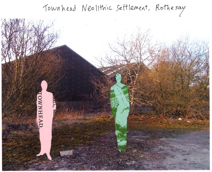
This paper comes at an early stage in my Walking Ludovic Mann project and in the coming months and years I intend to visit – and walk between – a wide range of locations of significance to Mann’s prehistoric Glasgow. Previous blog posts have reported on work Mann did outwith the city – Ferniegair cist cemetery for instance in South Lanarkshire, and Townhead Neolithic settlement on Bute. But I now want to retreat back to the city, to retrace the work of Mann with my feet, to see what remains of his secret grid and his sacred geometry beneath the fabric of this modern city.
The discoveries of Ludovic Mann in essence sketched out the structure of prehistoric Glasgow.
A Glasgow before it was Glasgow.
His eccentric research and eclectic interests allowed a different way of thinking about familiar Glasgow streets, landmarks and place names.
A map within a map. A city within a city. A secret map. A secret city.
His probing mind.
His dirty hands.
His obsessive measuring.
Mann’s voracious collecting.
Mann’s prehistoric fetishizing.
Mann’s insistent storytelling.
Mann’s underground city, Glasgow inverted, Glasgow’s past dragged back into the present, raised from the dead. Passing through wormholes. Tears in space and time.
Prehistoric Glasgow revealed – for all to see – if they care to look.
Secret geography. Sacred geometry.
Deep time.
Timeless. Effortless.
Walk and talk and chalk Ludovic McLellan Mann’s Glasgow.
Sources and acknowledgements:much of the biographical information in this lecture came from Graham Ritchie’s excellent paper Ludovic McLellan Mann (1869–1955): ‘the eminent archaeologist’, published in the Proceedings of the Society of Antiquaries of Scotland volume 132, pages 43-64 (2002). If you google it, you can find this article freely available online. The front cover of the Mann pamphlet and the route to get to and from Knappers were sourced thanks to this really helpful webpage which has scanned and reproduced various ‘earth mysteries’ books and pamphlets. Various images, sourced from the former RCAHMS, have been reproduced under their creative commons policy with image codes in the captions.
One of the key drivers behind this blog – and my urban prehistory project – is the sense that traces of activities and structures from the past persist within contemporary urban landscapes, to the extent that even when there are no visible remains left of whatever was there previously, there is nonetheless value to visiting those places, and in some instances, marking them in some way, drawing attention to them. And at times, tangible traces of the past jut into the present, sometimes in unexpected ways – if we are willing to look for them. This is one of the key traits of psychogeography too, the subversion of urban rigidity through the exploration of older spatial arrangements and purposes, in order to reveal an unexpected and invigorating way of engaging with modern urban homogeneity.
Psychogeographers rarely apply such approaches to prehistoric traces, and although that has been my focus to date, I understand the reasons for this. More recent structures and activities can much more easily reveal themselves in, for instance, street layouts, the kink of a wall, the location of a road junction, street names or the shape of a garden fence. Thus, recently, I stepped back from prehistory to look at a very different kind of structure that persists in recent memory in a very familiar urban landscape, the retail park. I wanted to explore to what extent the old football stadium of Hamilton Academical FC, Douglas Park, demolished in 1995, still has a material presence amidst a supermarket, fast food drive thru, assorted retails spaces and a big car park. My exploration of this urban space included, perhaps surprisingly, prehistoric allusions, and finished in another car park, that of the New Douglas Part stadium, within the structure of which is a brick with my name on it.
Douglas Park: 1888 to 1995
My walk started with a drive, to the supermarket car park where Douglas Park once stood (and for a map of this location, and my walk route, see the end of this post). There were ghosts in the car park as I left my car and walked through it. On the ground were white lines for parking spaces and junctions where once there were white lines defining penalty boxes and a halfway line. There are now bollards and signage where there were once goal posts. Shoppers drift past me pushing trolleys where once wingers drifted past defenders. I started my walk somewhere near the northern penalty box and away terrace had been, now in the shadow of the entrance of an orange and white supermarket, looking towards the South Lanarkshire Council high rise which dominates the horizon line.
Through the car park I walked, across where the pitch had once been, focused not on the shops there now but what was once here.
Then a familiar view – a grey low building, behind some trees and a fence. A familiar building, one that used to loom over the home terrace at old Douglas Park, a building I saw hundreds of times as I looked over towards the ramshackle shed stand on the east side of the stadium. It was also in full view during the short walk to the home turnstiles from Douglas Park Lane (now warped and bent into a new form, servicing the retail car park) – and upon entering the ground.
The same grey building viewed from the pitch in this photo from an Accies v Rangers game on 13th August 1988. The match shown is an Accies v Blackpool pre-season friendly, and Accies’ number 9 is Colin Harris.
Past this, nothing brought back memories other than Hamilton West railway station to my right. Otherwise, it was fast food and fuel, pavements and pedestrians. I left the car park and onto Clydesdale Street, where I walked past various 19th century sandstone buildings, now mostly commercial establishments like nurseries and dentists, with façades that afforded no view onto the location of old Douglas Park.
I turned left onto Douglas Street, the only street name that echoes the football ground that was once here. Across to the right is the huge Caird Street council car park that my dad and I used to park in before games.
To the left is that grey blocky building, like a pair of huge lego bricks arranged perpendicular to one another. This is currently a Community Health Clinic, and I walked into the empty car part (it being the weekend) to see if any traces of the old football ground survived. An old wall to my left looked promising but was not quite right in terms of being part of the infrastructure of the ground, while straight ahead was a modern looking and austere wooden fence, greening through neglect.
Round the corner, another wall, this one running down the side of the grey clinic and back to Douglas Street. This wall looked more promising, and I suspect it might well have been on the southern edge of the ground, quite possibly near one of the entrances for away supporters. The wall has writing on it, big yellow capital letters, although only the bottom half of the bold yellow phrase survives as the upper courses of red brick are gone, replaced by a wire fence. I am fairly sure the writing on the wall says:
OFFICAL PARKING ONLY
Is this related to the football ground? Probably given its location. And towards Douglas Street, I spotted a small rectangular piece of wood affixed to the wall just below head height. Seven courses of brick directly above it, symmetrically placed, was some kind of nail or screw, and between the two a stain. Is this the remnants of a plinth to which a sign was once fixed to guide supporters? Given its location on Douglas Street, across from the car park, this seems likely.
Sadly, nothing else was discerned on my walk, despite me accessing the garden of a dentist surgery, and later peeking behind an industrial unit. A few old brick walls were evident, parallel to the wall with the writing, although it is likely these define 19th century garden and property boundaries.
And so, 20 years after it was demolished, next to nothing remains of this football stadium, at least in situ. Pieces of this place were dispersed around central Scotland, and perhaps even further. The components of the stadium infrastructure ended up in different places after demolition – the turnstiles went to Brockville Park in Falkirk (itself demolished in 2003) and the stand was taken apart, and re-assembled at the ground of Auchinleck Talbot in Ayrshire (where for all I know it still stands today). Some of the floodlights used to be stored in a bus depot in Stonehouse if I remember correctly. How thoroughly the stadium was dissembled beyond these acts is unknown. Fixtures and fittings were no doubt kept as souvenirs by staff and fans, and it may well be that some turf from the ground was dug up and transplanted elsewhere after the last reserve game was played there in early 1995. Fans may have genuine Douglas Park bricks, or the penalty spot, in their garden. It is likely that bits and pieces are also stored in the New Douglas Park, or on display in the director’s boardroom, portable memories.
Aside from such relics, the material remains of this place are now gone.
How quickly it has been forgotten.
How rapidly this changed from a place of entertainment (!) and leisure to one of commerce and junk food.
And yet, it could be argued – and indeed the local Council have stated – that the replacement of the crumbling not-fit-for-purpose old Douglas Park with a supermarket and retail facility (and the subsequent construction of a second supermarket immediately behind the first one as part of the development of Accies’ New Douglas Park in the early 2000s) have been a major element in the regeneration of this area of Hamilton – Whitehill. This is a council housing estate which over the years has had a poor reputation and serious problems with drugs, unemployment and gang culture. A strategy over the last decade of improvements in facilities, tidying things up and installing public art could be viewed as a simplistic pseudo-capitalist solution to the problems of this area, but the Council’s own statistics seem to suggest it is working (although to what extent I am unsure).
Public art outside one of the supermarkets
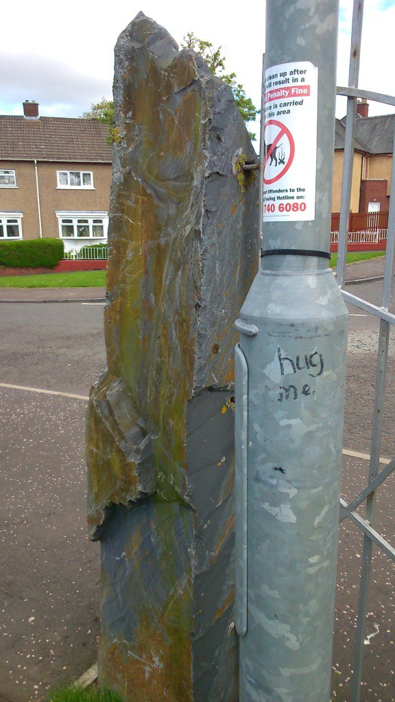
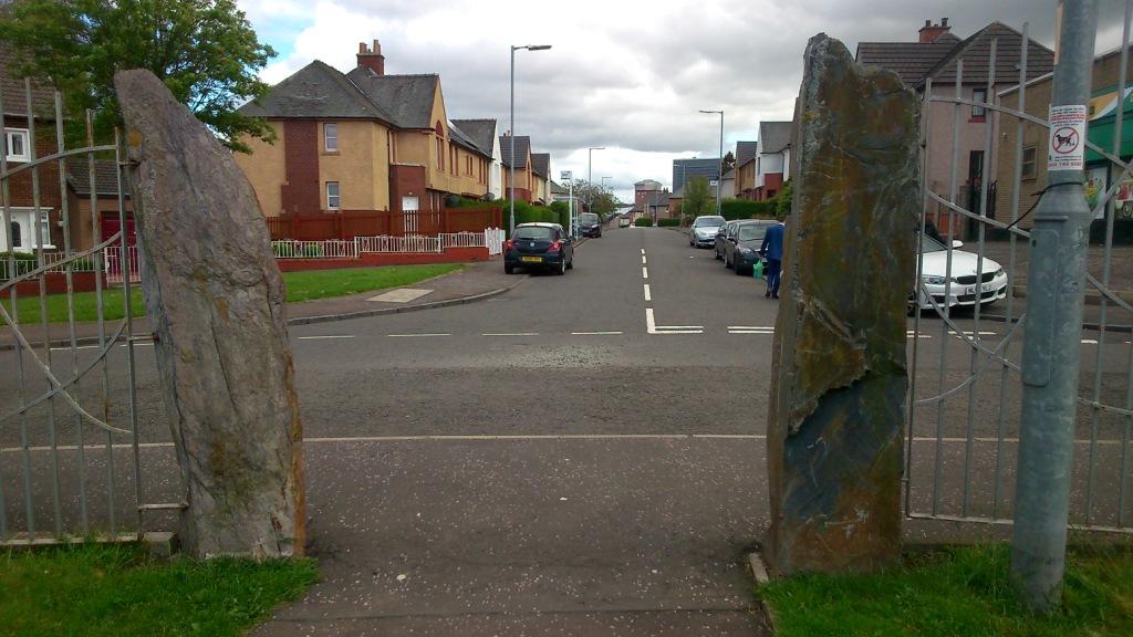
So from the ghostly car parks of old Douglas Park, I headed away from the double retail park (why are so many concrete places called ‘parks’?). Walking along Auchinraith Avenue I saw evidence of this regeneration – a new primary school and new secondary school, and then, a few hundred metres beyond this, at the junction with Margaret Road and Hunter Road, a new community centre. I had driven past this place a month or so previously and spotted standing stones at the road side, and so I wanted to go back and investigate. Sure enough, as I approached, ahead of me was a small grassy area (another park) at the rear of the Whitehill Neighbourhood Centre, adorned with various megaliths, the most obvious of which were four angled slate slabs supporting a gate and fence.
This is quite a peculiar arrangement, as it is clear that the nice metal gate supported by two of the standing stones is completely obsolete as the fence is insufficiently long to fence anything in. Even if the gate were closed and locked, one would not have to walk far get around this obstacle. So far, so-slightly-pointless public art.
Beyond this weird gate arrangement: a series of seriously megalithic benches, all concrete curves and cold edges, three shades of grey, arranged in several small circular arrangements, the geometrical pattern of which is only apparent from the air. I sat on one of the benches to send a tweet, but I was unable to find a comfortable way to perch upon them.
The bench did offer an excellent position from which to survey (as in look at, not carry out a full archaeological survey) a snaking row of standing stones, running down the slope from where I was sitting uneasily. There are twelve stones in all, with the smallest at the downhill end, graded towards the top of the monument. The only exception to this neat arrangement is a rather stubby knee-high stone at the higher end of the row. In plan, the stones are arranged in an S shape (the profile of a Bronze Age Beaker pot). The stones themselves were of a completely different character to the gate posts, made of what looked and felt like a reddish sandstone. (Note: sandstone is my default geological characterisation of any rock that isn’t obviously granite, marble or slate. That’s why when students ask me what stone a megalith is made from, I invariably answer immediately: “sandstone”.)
The stones are set into concrete, and stained with leopard-skin coloured lichen and in a few cases bird shit. Weeds grow painfully from the base of a few of the stones. One or two shows signs of having been written on. The tallest stone has a series of initials and letters written on it in blue paint, a columnar code, Hamilton hieroglyphs:
Shay
T
CS
Scored out letter(s)
BaE
A
Eg
Illegible word
Rectangle at an angle
Beside one of the gate post slabs is a lamp post, with these words written on it: hug me.
I didn’t.
hug me
This stylised arrangement of concrete, slate, sandstone and iron gave me a rather cold feeling, my immediate response being that this was the kind of tokenistic standing stone space fillers that crop up all over the place these days. The cold concrete benches and the curving row of stones had a certain kinaesthetic property that suggested dynamism, but on a quiet and chilly Sunday afternoon, this was a silent place. Perhaps with the buzz of children playing amidst the stones (yes, children of the stones) this becomes a very different place.
Thought to self: standing stones need people. And people apparently need standing stones.
Turning over a new leaf
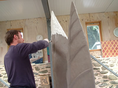
This new community facility and the new megaliths that accompany it are part of the aforementioned regeneration of Whitehill, and so it is fitting that an explicit piece of art here reflects this aspiration. On the other side of the concrete benches is a sculpture of two giant leaves. This is a piece called ‘Turning over a new leaf’, and was created by Rachan Design. It was designed with help from the ‘Whitehill youth group … to reflect regeneration within their community’ and is made of bronze and is 1.9m tall.
Making the leaves
Turning my back on this rather jumbled series of metal and stone uprights, I looked back between the slate standing stones, back along Auchinraith Road to where I had come from earlier on. There in the distance was a clock tower, but not that of a church; rather of a Morrisons supermarket.
Time is money.
The new suburbia.
Towards the clock tower
I couldn’t help reflect that the Council claims of improvements here might actually just be superficial and glossy, and perhaps not that inclusive. Rather than hang around in the new ‘high concept design space’ provided round the back of the community centre, a small group of local kids stood nearby at the true focal point of this part of Whitehill; a Day Today Express grocery store, Get Stuffed ice cream and takeaway, and Harper’s and Queens (hairdresser?). This block of shops seemed a million miles away from the shiny supermarkets which are actually less than a mile away.
The kids looked at me in a disinterested way. I’m used to it.
I do hope the standing stones have, or will, become a local focal point, a matter of pride, a conversation starter, that they serve some purpose. I hope they have not become obsolete just yet, or laughed at, or ignored.
Walking back towards the rear of the retail complex, I wandered round into yet another new car park, the largely empty one outside New Douglas Park. I reflected on the memories of the old stadium just a goal kick away from where I stood, and how improvements are certainly evident. The fortunes of the football club have improved since it moved location after some difficult years out of the town, and there is a sense that this is a community club, on the edge of Whitehill, contributing to the life of the town.
Running along the east side of the stadium, between a temporary stand (built solely, it seems, to house Celtic and Rangers fans) and the back of a supermarket, runs the recently created Hope Street. Here, we have more writing on the wall, but this is much more aspirational and forward looking than the defunct official notice I saw on the wall near where the old stadium had stood. This is part of the ongoing art project at NDP, the ‘Children’s Escape and Serenity Art Garden’. This fills a zone that skirts around the edges of the football pitch and includes a beach area and murals on the wall of the adjacent supermarket (this time acting as a giant canvas); it is run by the club’s Community Trust and the childrens’ charity Blameless and is a true community resource. One of the contributors to this garden is the Scottish artist Peter Howson – he opened it in 2012, and told The Herald at the time:
‘It’s an ongoing thing. It’s developing all the time. It’s a living energy and the people who all work here are incredible’.
Hope seems as good a place as any to end my walk.
Peter Howson at NDP – photo by Nick Ponty, initially published in The HeraldHope Street – and a floodlight
And so my walk finished with an unsatisfactory coffee in, where else, a supermarket. In a sense I was disappointed, as I found little material evidence of old Douglas Park. Somehow, in two decades, it had been almost wiped out. And look online – there is almost nothing there either, a few poor quality photos only. Virtually and literally there is nothing left, only memories and photos in private scrap books and forgotten envelopes in drawers.
And yet I detected something – an essence perhaps – channelled through my own memories. Because I spent literally hundreds of hours standing in the place that is now a car park, on the terraces, leaning on a metal barrier, spending time with my dad. When I walked to the ground with the grey concrete council building in front of me, I was walking along my own version of ‘Hope Street’ even it is was really just good old Douglas Park Lane. Places really can persist through emotion, memory, attachment – and no amount of urban cleansing can change this. Perhaps this sense will only persist as long as there are Hamilton Accies supporters (of a certain age) who visit this place, always aware of what was there before, what has been lost.
I’m not misty eyed and daft. Nothing endures forever. Change happens. In urban spaces and places this is especially true, and things have moved on now.
But memories abide.
I cannot visit this car park, this supermarket, thisplace, without it still being that place.
Old Douglas Park.
My route. Note the approx. location of old Douglas Park denoted by a faint black rectangle
Sources and acknowledgements: the colour photo of ODP from the south was printed in an article in The Scotsman in 2012, while the black and white football action shot came from an Accies programme (more information in the caption). Information on Whitehill and recent improvements can be found in various places e.g. this good practice case-study from the Scottish Government website about urban green space development. A little more on the Turning over a new leaf artwork can be found at the Rachan website (link in post) (and this was the source of the photo showing the sculpture being made).